|
search place name
|
||
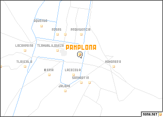
Pamplona (Durango, Mexico)Pamplona is a town in the Durango region of Mexico. An overview map of the region around Pamplona is displayed below.
regional and 3d topo map of Pamplona, Mexico ::
Pamplona airports ::
The nearest airport is TRC - Torreon Intl, located 58.9 km south of Pamplona.
Other airports nearby include LOV - Monclova Intl (214.4 km north east), DGO - Durango Intl (246.7 km south west), Nearby towns ::
La Ceceda (4.1km south west) //
Providencia (5.6km north) //
San Martin (5.6km south) //
Tlahualilo de Zaragoza (5.3km west) //
El Roble (5.8km south) //
Eva (6.5km north west) //
Mohonera (6.9km east) //
Rosas (7.5km north west) //
Iberia (7.6km south west) //
Holanda (8.1km south west) //
Jalapa (8.1km south west) //
[all distances 'as the bird flies' and approximate] 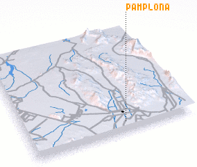 Places with similar names to Pamplona, Mexico ::
// Pamplona (PA)
// Pampaluna (IT)
// Pamplona (CU)
// Pamplin (US)
// Pampa Elena (CL)
// Pamplona (CO)
// Pamplona (CO)
// Pamplona (CO)
// Pamplona (PE)
// Pampelonne (FR)
Disclaimer :: Information on this page comes without warranty of any kind |
||
|
Where is Pamplona? Elevation and coordinates ::
Latitude (lat): 26°6'0"N Longitude (lon): 103°24'0"W
Elevation (approx.): 1093m (map arrows pan, magnifying glasses zoom) |
||
|
Visiting Pamplona? Hotel/Accommodation ::
Book a hotel in Pamplona Travel Guide ::
Buy a travel guide for Mexico rental cars ::
car rental offers GPS waypoint ::
download a GPX waypoint (PoI) of Pamplona for your GPS receiver
|
||