|
search place name
|
||
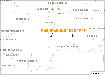
Peña Verde (Oaxaca, Mexico)Peña Verde is a town in the Oaxaca region of Mexico. An overview map of the region around Peña Verde is displayed below.
regional and 3d topo map of Peña Verde, Mexico ::
Peña Verde airports ::
The nearest airport is OAX - Oaxaca Xoxocotlan Intl, located 95.9 km south of Peña Verde.
Other airports nearby include TCN - Tehuacan (101.9 km north west), VER - Vera Cruz General Heriberto Jara Intl (152.4 km north), PXM - Puerto Escondido Intl (223.6 km south), PBC - Puebla Hermanos Serdan Intl (225.6 km north west), Nearby towns ::
San Juan Teponaxtla (3.9km south) //
San Alejo (4.3km north) //
Santiago Quetzalapa (5.8km east) //
San Pedro Sochiapan (6.7km south east) //
San Francisco Chapulapa (7.6km north) //
Río Hondo (8.0km north) //
Peña Verde (7.7km east) //
San Miguel Santa Flor (11.7km north west) //
[all distances 'as the bird flies' and approximate]  Places with similar names to Peña Verde, Mexico ::
// Pena Forte (BR)
// Pena Verde (PT)
// Poiana Frăţii (RO)
// Peñafurada (ES)
// Ponferrada (ES)
// Payne Ford (US)
// Peña Verde (MX)
// Peña Verde (MX)
// Pennifort (HT)
// Pen-ffordd (GB)
Disclaimer :: Information on this page comes without warranty of any kind |
||
|
Where is Peña Verde? Elevation and coordinates ::
Latitude (lat): 17°51'58"N Longitude (lon): 96°43'9"W
Elevation (approx.): 1841m (map arrows pan, magnifying glasses zoom) |
||
|
Visiting Peña Verde? Hotel/Accommodation ::
Book a hotel in Peña Verde Travel Guide ::
Buy a travel guide for Mexico rental cars ::
car rental offers GPS waypoint ::
download a GPX waypoint (PoI) of Peña Verde for your GPS receiver
|
||