|
search place name
|
||
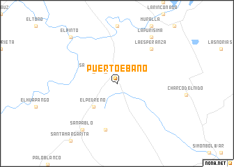
Puerto Ébano (Tamaulipas, Mexico)Puerto Ébano is a town in the Tamaulipas region of Mexico. An overview map of the region around Puerto Ébano is displayed below.
regional and 3d topo map of Puerto Ébano, Mexico ::
Puerto Ébano airports ::
The nearest airport is MAM - Matamoros General Servando Canales Intl, located 133.2 km north east of Puerto Ébano.
Other airports nearby include CVM - Ciudad Victoria General Pedro Jose Mendez Intl (141.0 km south west), REX - Reynosa General Lucio Blanco Intl (149.8 km north), BRO - Brownsville South Padre Island Intl (151.1 km north east), MFE - Mcallen Mc Allen Miller Intl (168.3 km north), Nearby towns ::
La Peregrina (2.5km north west) //
San Antonio (3.8km north west) //
El Pedreño (5.0km south west) //
El Tanque (7.6km south) //
La Esperanza (7.5km north east) //
La Purísima (9.0km north east) //
San Pablo (9.0km south west) //
El Pinto (10.0km north west) //
[all distances 'as the bird flies' and approximate]  Places with similar names to Puerto Ébano, Mexico ::
// Port Ben (US)
// Páratebien (CO)
// Páratebien (CO)
// Paratebueno (CO)
// Paratebueno (CO)
// Paratebueno (CO)
// Páratebueno (CO)
// Parate Bueno (VE)
// Parate Bueno (VE)
// Párate Bueno (VE)
Disclaimer :: Information on this page comes without warranty of any kind |
||
|
Where is Puerto Ébano? Elevation and coordinates ::
Latitude (lat): 24°40'0"N Longitude (lon): 98°3'0"W
Elevation (approx.): 56m (map arrows pan, magnifying glasses zoom) |
||
|
Visiting Puerto Ébano? Hotel/Accommodation ::
Book a hotel in Puerto Ébano Travel Guide ::
Buy a travel guide for Mexico rental cars ::
car rental offers GPS waypoint ::
download a GPX waypoint (PoI) of Puerto Ébano for your GPS receiver
|
||