|
search place name
|
||
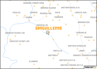
San Guillermo (Oaxaca, Mexico)San Guillermo is a town in the Oaxaca region of Mexico. An overview map of the region around San Guillermo is displayed below.
regional and 3d topo map of San Guillermo, Mexico ::
San Guillermo airports ::
The nearest airport is OAX - Oaxaca Xoxocotlan Intl, located 64.5 km north of San Guillermo.
Other airports nearby include PXM - Puerto Escondido Intl (70.8 km south west), HUX - Bahias Dehuatulco Bahias De Huatulco Intl (87.0 km south east), Nearby towns ::
San Simón Almolongas (2.6km south east) //
San Nicolás (3.3km north west) //
La Cañada (5.8km north) //
Río Anona (6.9km north east) //
Agua del Sol (7.1km north) //
El Zompantle (7.5km north east) //
San José Llano Grande (7.5km east) //
Guixé (8.2km north east) //
Portillo (8.2km south east) //
La Noria (9.1km north west) //
Yogana (9.0km north west) //
[all distances 'as the bird flies' and approximate]  Places with similar names to San Guillermo, Mexico ::
// San Guillermo (CO)
// San Guillermo (EC)
// San Guillermo (EC)
// San Guillermo (EC)
// San Guillermo (MX)
// San Guillermo (MX)
// San Guillermo (MX)
// San Guillermo (MX)
// San Guillermo (MX)
// San Guillermo (MX)
Disclaimer :: Information on this page comes without warranty of any kind |
||
|
Where is San Guillermo? Elevation and coordinates ::
Latitude (lat): 16°25'0"N Longitude (lon): 96°44'0"W
Elevation (approx.): 1477m (map arrows pan, magnifying glasses zoom) |
||
|
Visiting San Guillermo? Hotel/Accommodation ::
Book a hotel in San Guillermo Travel Guide ::
Buy a travel guide for Mexico rental cars ::
car rental offers GPS waypoint ::
download a GPX waypoint (PoI) of San Guillermo for your GPS receiver
|
||