|
search place name
|
||
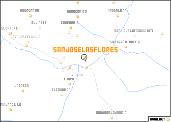
San José Las Flores (Oaxaca, Mexico)San José Las Flores is a town in the Oaxaca region of Mexico. An overview map of the region around San José Las Flores is displayed below.
regional and 3d topo map of San José Las Flores, Mexico ::
San José Las Flores airports ::
The nearest airport is OAX - Oaxaca Xoxocotlan Intl, located 89.1 km north west of San José Las Flores.
Other airports nearby include HUX - Bahias Dehuatulco Bahias De Huatulco Intl (99.0 km south), PXM - Puerto Escondido Intl (144.4 km south west), MTT - Minatitlan (221.1 km north east), TCN - Tehuacan (256.8 km north west), Nearby towns ::
Nejapa de Madero (1.4km south) //
Las Casillas (3.7km west) //
La Unión (4.6km south west) //
La Mancomada (4.6km west) //
Las Ánimas (5.2km west) //
El Gramal (5.3km south west) //
Soledad Salinas (5.9km north) //
Isidro (6.1km south west) //
Agua Blanca (7.3km north west) //
Chavarría (7.9km north west) //
El Camarón (8.9km south west) //
Santa Ana Tavela (8.9km east) //
[all distances 'as the bird flies' and approximate] 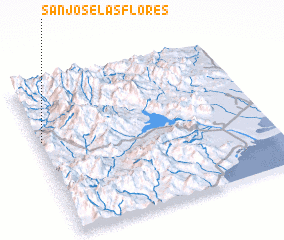 Places with similar names to San José Las Flores, Mexico ::
// San José Las Flores (SV)
// San José Las Flores (SV)
// San José Las Flores (GT)
// San José Las Flores (GT)
Disclaimer :: Information on this page comes without warranty of any kind |
||
|
Where is San José Las Flores? Elevation and coordinates ::
Latitude (lat): 16°37'44"N Longitude (lon): 95°59'5"W
Elevation (approx.): 658m (map arrows pan, magnifying glasses zoom) |
||
|
Visiting San José Las Flores? Hotel/Accommodation ::
Book a hotel in San José Las Flores Travel Guide ::
Buy a travel guide for Mexico rental cars ::
car rental offers GPS waypoint ::
download a GPX waypoint (PoI) of San José Las Flores for your GPS receiver
|
||