|
search place name
|
||
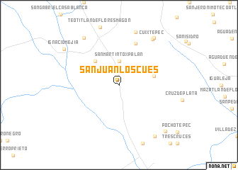
San Juan Los Cues (Oaxaca, Mexico)San Juan Los Cues is a town in the Oaxaca region of Mexico. An overview map of the region around San Juan Los Cues is displayed below.
regional and 3d topo map of San Juan Los Cues, Mexico ::
San Juan Los Cues airports ::
The nearest airport is TCN - Tehuacan, located 63.1 km north west of San Juan Los Cues.
Other airports nearby include OAX - Oaxaca Xoxocotlan Intl (121.2 km south), VER - Vera Cruz General Heriberto Jara Intl (151.7 km north east), PBC - Puebla Hermanos Serdan Intl (185.7 km north west), TXA - Tlaxcala (202.9 km north west), Nearby towns ::
San Martín Toxpalan (3.7km north) //
Ayotla (5.1km north west) //
La Nopalera (5.4km east) //
Vista Hermosa (7.0km north) //
Capultitla (8.7km north) //
Cuixtepec (8.8km north east) //
San Antonio Nanahuatipan (9.1km north west) //
San Bernardino (9.1km north east) //
Santiago Viejo (9.7km south east) //
Ignacio Mejia (10.0km north west) //
Peña Blanca (10.1km south east) //
[all distances 'as the bird flies' and approximate]  Places with similar names to San Juan Los Cues, Mexico :: Disclaimer :: Information on this page comes without warranty of any kind |
||
|
Where is San Juan Los Cues? Elevation and coordinates ::
Latitude (lat): 18°3'0"N Longitude (lon): 97°3'0"W
Elevation (approx.): 897m (map arrows pan, magnifying glasses zoom) |
||
|
Visiting San Juan Los Cues? Hotel/Accommodation ::
Book a hotel in San Juan Los Cues Travel Guide ::
Buy a travel guide for Mexico rental cars ::
car rental offers GPS waypoint ::
download a GPX waypoint (PoI) of San Juan Los Cues for your GPS receiver
|
||