|
search place name
|
||
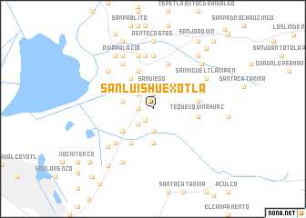
San Luis Huexotla (México, Mexico)San Luis Huexotla is a town in the México region of Mexico. An overview map of the region around San Luis Huexotla is displayed below.
regional and 3d topo map of San Luis Huexotla, Mexico ::
San Luis Huexotla airports ::
The nearest airport is MEX - Mexico City Licenciado Benito Juarez Intl, located 22.0 km west of San Luis Huexotla.
Other airports nearby include PBC - Puebla Hermanos Serdan Intl (62.8 km south east), PCA - Pachuca Ingeniero Juan Guillermo Villasana (67.2 km north), TXA - Tlaxcala (73.1 km east), TLC - Toluca Licenciado Adolfo Lopez Mateos Intl (75.0 km west), Nearby towns ::
Lomas de San Esteban (1.6km south west) //
La Via Lactea (1.7km west) //
La Trinidad de Axopilco (1.9km north) //
Boyero (2.5km north west) //
Santa Rosa (2.5km south west) //
San Diego (2.8km north) //
San Miguel Coatlinchán (2.8km south) //
Chapingo (3.6km west) //
Tepetitlán (4.2km south) //
Santa Cruz de Abajo (4.5km north west) //
San Bernardino (4.5km south west) //
Montecillo (4.5km south west) //
Natívitas (4.5km north east) //
Texcoco de Mora (5.0km north) //
El Mexcatillo (4.9km south west) //
San Dieguito Xochimanca (5.3km east) //
Tequexquinahuac (5.3km east) //
Xocotlán (5.8km north) //
El Tejocote (6.0km south west) //
Texopa (6.5km north) //
Tulantengo (6.5km north) //
Tocuila (6.6km north west) //
Chiautla (6.7km north) //
San Salvador Atenco (7.0km north west) //
Los Laureles (7.0km south west) //
Riva Palacio (7.4km north west) //
Santiago Cuautlalpan (7.4km south west) //
Santa María Chimalhuacán (7.4km south west) //
Chicoloapan de Juárez (7.4km south west) //
[all distances 'as the bird flies' and approximate] 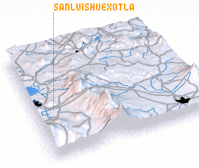 Places with similar names to San Luis Huexotla, Mexico :: Disclaimer :: Information on this page comes without warranty of any kind |
||
|
Where is San Luis Huexotla? Elevation and coordinates ::
Latitude (lat): 19°28'30"N Longitude (lon): 98°52'0"W
Elevation (approx.): 2290m (map arrows pan, magnifying glasses zoom) |
||
|
Visiting San Luis Huexotla? Hotel/Accommodation ::
Book a hotel in San Luis Huexotla Travel Guide ::
Buy a travel guide for Mexico rental cars ::
car rental offers GPS waypoint ::
download a GPX waypoint (PoI) of San Luis Huexotla for your GPS receiver
|
||