|
search place name
|
||
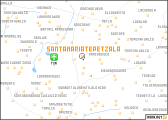
Santa María Tepetzala (Tlaxcala, Mexico)Santa María Tepetzala is a town in the Tlaxcala region of Mexico. An overview map of the region around Santa María Tepetzala is displayed below.
regional and 3d topo map of Santa María Tepetzala, Mexico ::
Santa María Tepetzala airports ::
The nearest airport is TXA - Tlaxcala, located 6.3 km west of Santa María Tepetzala.
Other airports nearby include PBC - Puebla Hermanos Serdan Intl (49.4 km south west), PCA - Pachuca Ingeniero Juan Guillermo Villasana (92.5 km north west), MEX - Mexico City Licenciado Benito Juarez Intl (101.2 km west), TCN - Tehuacan (135.9 km south east), Nearby towns ::
Zocac (1.7km south) //
San Pedro Ecatepec (2.0km west) //
San Antonio Chapultepec (2.8km north) //
Villa de las Flores (2.9km south) //
Agua Escondida (2.9km north east) //
Rancho Seco (3.4km east) //
Plan de Ayala (3.8km south) //
Nopala (3.8km south) //
Zololuca (3.7km east) //
La Martinica (4.8km north west) //
Tetechilco (5.8km north east) //
Xalostoc (6.6km north east) //
San Baltzar (6.6km north west) //
San Cosme (6.8km north) //
La Trasquila (6.5km west) //
Dolores (6.9km south) //
Totelcapa (6.9km north) //
San Bartolomé Metlalohcan (7.3km south) //
Ahuatepec (7.3km south) //
San Luis (7.1km north west) //
San Francisco Atezcatzinco (7.5km south) //
Piedras Negras (7.3km south east) //
Tetla Cuarta Sección (7.9km south) //
El Potrero (7.7km north east) //
José María Morelos y Pavón (7.8km south east) //
Santa Clara Ozumba (8.0km north west) //
Capula (7.9km east) //
Las Casitas (8.4km north east) //
Morelos (8.6km south west) //
[all distances 'as the bird flies' and approximate]  Places with similar names to Santa María Tepetzala, Mexico :: Disclaimer :: Information on this page comes without warranty of any kind |
||
|
Where is Santa María Tepetzala? Elevation and coordinates ::
Latitude (lat): 19°31'55"N Longitude (lon): 98°6'50"W
Elevation (approx.): 2626m (map arrows pan, magnifying glasses zoom) |
||
|
Visiting Santa María Tepetzala? Hotel/Accommodation ::
Book a hotel in Santa María Tepetzala Travel Guide ::
Buy a travel guide for Mexico rental cars ::
car rental offers GPS waypoint ::
download a GPX waypoint (PoI) of Santa María Tepetzala for your GPS receiver
|
||