|
search place name
|
||
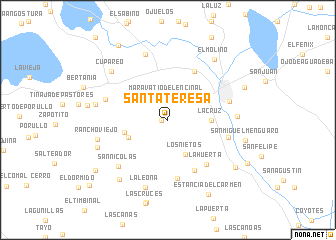
Santa Teresa (Guanajuato, Mexico)Santa Teresa is a town in the Guanajuato region of Mexico. An overview map of the region around Santa Teresa is displayed below.
regional and 3d topo map of Santa Teresa, Mexico ::
Santa Teresa airports ::
The nearest airport is MLM - Morelia General Francisco J Mujica Intl, located 37.6 km south of Santa Teresa.
Other airports nearby include QRO - Queretaro Intercontinental (94.0 km north east), BJX - Del Bajio Guanajuato Intl (104.8 km north west), ZMM - Zamora (138.4 km west), UPN - Uruapan Licenciado Y Gen Ignacio Lopez Rayon (142.7 km south west), Nearby towns ::
Cuatro Esquinas (0.7km west) //
Maravatío del Encinal (2.5km north) //
Los Nietos (4.2km south east) //
Santiago Maravatío (4.6km south west) //
La Cruz (4.6km east) //
El Baño (4.8km west) //
Santo Tomás (6.1km north east) //
La Palma (6.3km south east) //
La Huerta (6.4km south east) //
La Presa (6.6km south) //
Eménguaro (6.6km east) //
Janicho (6.7km east) //
Cervacio Mendoza (6.9km west) //
San Nicolás (7.3km south west) //
San Pedro de los Naranjos (7.7km north) //
El Pocho (7.3km east) //
La Leona (7.9km south) //
Rancho Viejo (7.7km west) //
Santiaguillo (7.8km west) //
Cupareo (8.0km north west) //
La Joyita (8.0km south west) //
El Molino (8.3km north east) //
La Pila (8.4km south west) //
San Miguel Menguaro (8.4km east) //
Las Cañas (8.9km south east) //
Salvatierra (8.8km north east) //
Estancia del Carmen (9.4km south east) //
Ojo de Agua (9.5km south west) //
Puerta del Monte (9.8km north west) //
[all distances 'as the bird flies' and approximate]  Places with similar names to Santa Teresa, Mexico ::
// Santa Teresa (BR)
// Santa Teresa (BR)
// Santa Teresa (BR)
// Santa Teresa (BR)
// Santa Teresa (BR)
// Santa Teresa (BR)
// Santa Teresa (BR)
// Santa Teresa (BR)
// Santa Teresa (BR)
// Santa Teresa (BR)
Disclaimer :: Information on this page comes without warranty of any kind |
||
|
Where is Santa Teresa? Elevation and coordinates ::
Latitude (lat): 20°11'3"N Longitude (lon): 100°57'37"W
Elevation (approx.): 1762m (map arrows pan, magnifying glasses zoom) |
||
|
Visiting Santa Teresa? Hotel/Accommodation ::
Book a hotel in Santa Teresa Travel Guide ::
Buy a travel guide for Mexico rental cars ::
car rental offers GPS waypoint ::
download a GPX waypoint (PoI) of Santa Teresa for your GPS receiver
|
||