|
search place name
|
||
Santiago Teyahualco (México, Mexico)Santiago Teyahualco is a town in the México region of Mexico. An overview map of the region around Santiago Teyahualco is displayed below.
regional and 3d topo map of Santiago Teyahualco, Mexico ::

Santiago Teyahualco airports ::
The nearest airport is MEX - Mexico City Licenciado Benito Juarez Intl, located 25.3 km south of Santiago Teyahualco.
Other airports nearby include TLC - Toluca Licenciado Adolfo Lopez Mateos Intl (58.3 km south west), PCA - Pachuca Ingeniero Juan Guillermo Villasana (58.7 km north east), CVJ - Cuernavaca General Mariano Matamoros (92.3 km south), PBC - Puebla Hermanos Serdan Intl (96.8 km south east), Nearby towns ::
Diez de Junio (1.4km west) //
Tultepec (2.9km north) //
Santa María Cuautepec (2.9km south) //
San Pablo de las Salinas (3.3km east) //
Coacalco (3.5km south east) //
Villa de las Flores (3.5km east) //
San Mateo Cuautepec (3.9km south) //
San Pablo (4.2km east) //
Tultitlán (4.8km west) //
Melchor Ocampo (5.0km north west) //
Cuidad Labor (5.0km south west) //
Unidad José María Morelos y Pavón (5.2km north east) //
Tenopalco (5.9km north) //
Visitación (6.2km north) //
Cuautitlán (6.0km west) //
San Sebastían Xhala (6.6km north west) //
Buenavista (7.1km south west) //
San Lorenzo Tetlixtac (6.9km south east) //
San Mateo Ixtacalco (7.0km north west) //
Santa María (7.7km north west) //
Ciudad Labor (7.8km south west) //
Acamoa (7.7km west) //
Cárdenas (7.7km west) //
Santa María Tonatitla (7.9km east) //
Guadalupe Victoria (8.2km south east) //
San Bartolo (8.6km north west) //
Santa Bárbara (8.7km north west) //
Tepalcapa (9.0km south west) //
Santiago Atocan (9.6km north east) //
[all distances 'as the bird flies' and approximate] 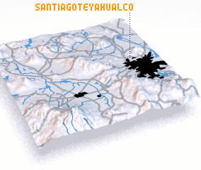 Places with similar names to Santiago Teyahualco, Mexico :: Disclaimer :: Information on this page comes without warranty of any kind |
||
|
Where is Santiago Teyahualco? Elevation and coordinates ::
Latitude (lat): 19°39'32"N Longitude (lon): 99°7'37"W
Elevation (approx.): 2247m (map arrows pan, magnifying glasses zoom) |
||
|
Visiting Santiago Teyahualco? Hotel/Accommodation ::
Book a hotel in Santiago Teyahualco Travel Guide ::
Buy a travel guide for Mexico rental cars ::
car rental offers GPS waypoint ::
download a GPX waypoint (PoI) of Santiago Teyahualco for your GPS receiver
|
||