|
search place name
|
||
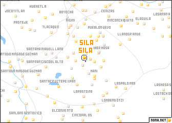
Sila (México, Mexico)Sila is a town in the México region of Mexico. An overview map of the region around Sila is displayed below.
regional and 3d topo map of Sila, Mexico ::
Sila airports ::
The nearest airport is TLC - Toluca Licenciado Adolfo Lopez Mateos Intl, located 32.2 km south of Sila.
Other airports nearby include MEX - Mexico City Licenciado Benito Juarez Intl (63.9 km east), CVJ - Cuernavaca General Mariano Matamoros (95.7 km south east), PCA - Pachuca Ingeniero Juan Guillermo Villasana (104.2 km north east), QRO - Queretaro Intercontinental (124.1 km north west), Nearby towns ::
Loma Hidalgo (1.0km north east) //
San Felipe Santiago (1.1km south west) //
Sila (1.6km north) //
Mañí (1.7km east) //
Buenos Aires (2.2km west) //
Loma Hidalgo (2.7km south) //
San José del Sitio (3.2km north west) //
Loma Hermosa (3.2km north east) //
San José del Sitio (3.3km south west) //
Colorado (3.3km east) //
Loma Hermosa (3.4km north east) //
Mañí (3.6km south east) //
San Bartolo Oxtotitlán (3.6km east) //
Rancho Alegre (3.8km west) //
San Felipe (4.1km south east) //
Santa Lucía (4.1km north) //
Loma San Felipe Santiago (4.6km south west) //
Loma de Malacota (4.9km north west) //
Tlalpujahuilla (5.1km north east) //
Mastejé (5.2km south) //
San Lorenzo Malacota (5.2km north east) //
Llano Grande (5.4km south) //
Santa Lucia (5.6km north) //
Santa María Nativitas (5.9km south east) //
Loma de Malacota (6.1km north west) //
Tlalpujahuilla (6.1km north east) //
Dolores Amarillas (6.3km west) //
San Lorenzo Malacota (6.6km north east) //
Pueblo Nuevo (6.9km north east) //
[all distances 'as the bird flies' and approximate] 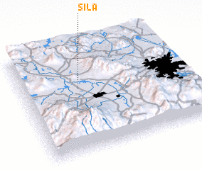 Places with similar names to Sila, Mexico ::
Disclaimer :: Information on this page comes without warranty of any kind |
||
|
Where is Sila? Elevation and coordinates ::
Latitude (lat): 19°37'0"N Longitude (lon): 99°39'0"W
Elevation (approx.): 2585m (map arrows pan, magnifying glasses zoom) |
||
|
Visiting Sila? Hotel/Accommodation ::
Book a hotel in Sila Travel Guide ::
Buy a travel guide for Mexico rental cars ::
car rental offers GPS waypoint ::
download a GPX waypoint (PoI) of Sila for your GPS receiver
|
||