|
search place name
|
||
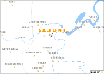
Sulchilapan (Oaxaca, Mexico)Sulchilapan is a town in the Oaxaca region of Mexico. An overview map of the region around Sulchilapan is displayed below.
regional and 3d topo map of Sulchilapan, Mexico ::
Sulchilapan airports ::
The nearest airport is MTT - Minatitlan, located 89.5 km north east of Sulchilapan.
Other airports nearby include OAX - Oaxaca Xoxocotlan Intl (190.1 km west), HUX - Bahias Dehuatulco Bahias De Huatulco Intl (225.0 km south west), TGZ - Tuxtla Gutierrez Angel Albino Corzo (228.3 km south east), VER - Vera Cruz General Heriberto Jara Intl (231.7 km north west), Nearby towns ::
Colombia (2.5km south east) //
San Martín (2.8km west) //
San Isidro (5.1km south) //
Tepachillo (5.8km east) //
Jesús Carranza (6.5km north west) //
Felicidad (6.8km south) //
Los Muertos (6.8km west) //
Las Perlas (7.9km east) //
Mixtequilla (8.7km south) //
Doña Mariana (9.0km south) //
Palo Dulce (8.7km west) //
Martín Dehesa (9.2km south west) //
[all distances 'as the bird flies' and approximate] 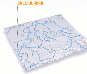 Places with similar names to Sulchilapan, Mexico :: Disclaimer :: Information on this page comes without warranty of any kind |
||
|
Where is Sulchilapan? Elevation and coordinates ::
Latitude (lat): 17°23'41"N Longitude (lon): 94°59'15"W
Elevation (approx.): 29m (map arrows pan, magnifying glasses zoom) |
||
|
Visiting Sulchilapan? Hotel/Accommodation ::
Book a hotel in Sulchilapan Travel Guide ::
Buy a travel guide for Mexico rental cars ::
car rental offers GPS waypoint ::
download a GPX waypoint (PoI) of Sulchilapan for your GPS receiver
|
||