|
search place name
|
||
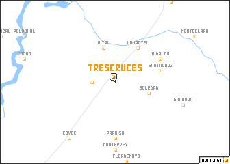
Tres Cruces (Campeche, Mexico)Tres Cruces is a town in the Campeche region of Mexico. An overview map of the region around Tres Cruces is displayed below.
regional and 3d topo map of Tres Cruces, Mexico ::
Tres Cruces airports ::
The nearest airport is CME - Ciudad Del Carmen Intl, located 74.0 km west of Tres Cruces.
Other airports nearby include CPE - Campeche Ingeniero Alberto Acuna Ongay Intl (159.5 km north east), VSA - Villahermosa C P A Carlos Rovirosa Intl (188.3 km west), TGZ - Tuxtla Gutierrez Angel Albino Corzo (295.2 km south west), Nearby towns ::
Santa Cruz de los Altos (3.5km west) //
Pital (5.8km north) //
Soledad (5.6km east) //
Mamantel (6.6km north east) //
Santa Cruz (7.3km east) //
Hidalgo (7.9km north east) //
[all distances 'as the bird flies' and approximate] 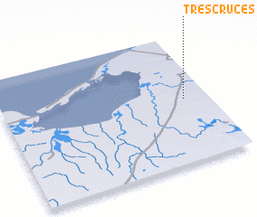 Places with similar names to Tres Cruces, Mexico ::
// Tres Cruces (BO)
// Tres Cruces (BO)
// Tres Cruces (BO)
// Tres Cruces (BO)
// Tres Cruces (BO)
// Tres Cruces (BO)
// Tres Cruces (BO)
// Tres Cruces (BO)
// Tres Cruces (BO)
// Tres Cruces (CU)
Disclaimer :: Information on this page comes without warranty of any kind |
||
|
Where is Tres Cruces? Elevation and coordinates ::
Latitude (lat): 18°30'0"N Longitude (lon): 91°7'0"W
Elevation (approx.): 9m (map arrows pan, magnifying glasses zoom) |
||
|
Visiting Tres Cruces? Hotel/Accommodation ::
Book a hotel in Tres Cruces Travel Guide ::
Buy a travel guide for Mexico rental cars ::
car rental offers GPS waypoint ::
download a GPX waypoint (PoI) of Tres Cruces for your GPS receiver
|
||