|
search place name
|
||
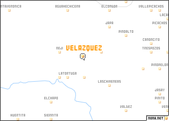
Velazquez (Baja California, Mexico)Velazquez is a town in the Baja California region of Mexico. An overview map of the region around Velazquez is displayed below.
regional and 3d topo map of Velazquez, Mexico ::
Velazquez airports ::
The nearest airport is NJK - El Centro Naf, located 72.4 km north east of Velazquez.
Other airports nearby include ESE - Ensenada (73.1 km south west), TIJ - Tijuana General Abelardo L Rodriguez Intl (73.4 km west), CXL - Calexico Intl (74.1 km north east), MXL - Mexicali General Rodolfo Sanchez Taboada Intl (96.2 km east), Nearby towns ::
El Compadre (3.7km south) //
Cinco Robles (3.6km north east) //
La Tortuga (4.9km south west) //
Nejí (5.0km west) //
El Tapirito (6.0km south west) //
Las Chimeneas (7.3km south east) //
Japá (8.8km north east) //
[all distances 'as the bird flies' and approximate] 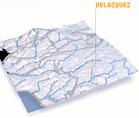 Places with similar names to Velazquez, Mexico ::
// Fallascoso (IT)
// Villaescusa (ES)
// Villaescusa (ES)
// Villaescusa (ES)
// Velasquez (US)
// Velásquez (CO)
// Velásquez (GT)
// Velázquez (MX)
// Velázquez (MX)
// Velázquez (MX)
Disclaimer :: Information on this page comes without warranty of any kind |
||
|
Where is Velazquez? Elevation and coordinates ::
Latitude (lat): 32°22'0"N Longitude (lon): 116°13'0"W
Elevation (approx.): 1207m (map arrows pan, magnifying glasses zoom) |
||
|
Visiting Velazquez? Hotel/Accommodation ::
Book a hotel in Velazquez Travel Guide ::
Buy a travel guide for Mexico rental cars ::
car rental offers GPS waypoint ::
download a GPX waypoint (PoI) of Velazquez for your GPS receiver
|
||