|
search place name
|
||
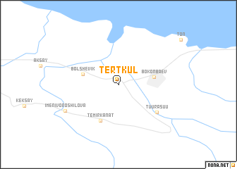
Tërt-Kul' (Issyk-Kul'skaya Oblast', Kyrgyzstan)Tërt-Kul' is a town in the Issyk-Kul'skaya Oblast' region of Kyrgyzstan. An overview map of the region around Tërt-Kul' is displayed below.
regional and 3d topo map of Tërt-Kul', Kyrgyzstan ::
Tërt-Kul' airports ::
The nearest airport is ALA - Alma-ata Almaty, located 138.8 km north of Tërt-Kul'.
Nearby towns ::
Bokonbayevo (4.4km east) //
Bökönbaev (4.4km east) //
Bol'shevik (4.5km west) //
Temir-Kanat (6.1km south) //
Tuura-Suu (6.3km south east) //
Imeni Voroshilova (7.5km south west) //
[all distances 'as the bird flies' and approximate]  Places with similar names to Tërt-Kul', Kyrgyzstan ::
// Tartagal (BO)
// Douar Doukkala (MA)
// Tortuguilla (PA)
// Tortuguilla (CU)
// Tardáguila (ES)
// Tortugal (CR)
// Törtköl (KZ)
// Törtköl (KZ)
// Tŭrtkŭl (UZ)
// Daré Diagal (SN)
Disclaimer :: Information on this page comes without warranty of any kind |
||
|
Where is Tërt-Kul'? Elevation and coordinates ::
Latitude (lat): 42°6'17"N Longitude (lon): 76°56'32"E
Elevation (approx.): 1803m (map arrows pan, magnifying glasses zoom) |
||
|
Visiting Tërt-Kul'? Hotel/Accommodation ::
Book a hotel in Tërt-Kul' Travel Guide ::
Buy a travel guide for Kyrgyzstan rental cars ::
car rental offers GPS waypoint ::
download a GPX waypoint (PoI) of Tërt-Kul' for your GPS receiver
|
||