|
search place name
|
||
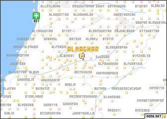
Al Maghār (Mont-Liban, Lebanon)Al Maghār is a town in the Mont-Liban region of Lebanon. An overview map of the region around Al Maghār is displayed below.
regional and 3d topo map of Al Maghār, Lebanon ::
Al Maghār airports ::
The nearest airport is BEY - Beirut Rafic Hariri Intl, located 13.1 km north west of Al Maghār.
Other airports nearby include RPN - Rosh Pina Mahanaim I Ben Yaakov (83.4 km south), DAM - Damascus Intl (93.6 km east), HFA - Haifa (114.2 km south west), OMF - Mafraq King Hussein (165.2 km south east), Nearby towns ::
‘Ayn Trāz (0.0km north) //
Mazraat Aatâya (0.9km south east) //
Er Rikn (1.3km south) //
Chartoûn (1.3km north west) //
El Hoûrânîyé (1.5km north west) //
Rishmayyā (1.4km east) //
Rimḩālā (1.5km west) //
Jisr al Qāḑī (1.5km west) //
‘Ammīq (1.9km south) //
Al Balāţ (1.5km west) //
Al Knaysah (1.9km south) //
Kafr Qaţrā (1.9km south) //
Silfāyā (1.5km west) //
Duwayr ar Rummān (1.9km north) //
Shartūn (1.9km north) //
Bū Zuraydah (1.9km north) //
El Kharjé (1.8km south west) //
Bnémchîne (2.0km south east) //
Kafr Ḩammil (2.4km south west) //
Dayr Kūshah (2.4km south west) //
Ad Duwayr (2.4km south east) //
Shwīt (2.4km south east) //
Mazra‘at ar Ruʼaysah (2.4km north west) //
Majdalayyā (2.4km north west) //
Ḩārat al Bustān (2.4km north west) //
Dfūn (2.4km north west) //
Ruʼaysat an Nu‘mān (2.4km north east) //
Mqoufti (2.4km south east) //
Ech Chehhâr (2.5km west) //
[all distances 'as the bird flies' and approximate]  Places with similar names to Al Maghār, Lebanon ::
// Almafrá (ES)
// Almofrey (ES)
// Al Amghar (SA)
// Al Mugharah (SA)
// Al Mafrī (SD)
// Al Mughayyir (JO)
// Al Mughayyir (JO)
// Al Maghārah (SY)
// Al Mughayr (SY)
// Al Mughayr (SY)
Disclaimer :: Information on this page comes without warranty of any kind |
||
|
Where is Al Maghār? Elevation and coordinates ::
Latitude (lat): 33°44'0"N Longitude (lon): 35°35'0"E
Elevation (approx.): 617m (map arrows pan, magnifying glasses zoom) |
||
|
Visiting Al Maghār? Hotel/Accommodation ::
Book a hotel in Al Maghār Travel Guide ::
Buy a travel guide for Lebanon rental cars ::
car rental offers GPS waypoint ::
download a GPX waypoint (PoI) of Al Maghār for your GPS receiver
|
||