|
search place name
|
||
Ḩalbatā (Béqaa, Lebanon)Ḩalbatā is a town in the Béqaa region of Lebanon. An overview map of the region around Ḩalbatā is displayed below.
regional and 3d topo map of Ḩalbatā, Lebanon ::

Ḩalbatā airports ::
The nearest airport is BEY - Beirut Rafic Hariri Intl, located 87.5 km south west of Ḩalbatā.
Other airports nearby include DAM - Damascus Intl (95.5 km south), LTK - Latakia Bassel Al Assad Intl (131.3 km north), RPN - Rosh Pina Mahanaim I Ben Yaakov (155.5 km south west), HFA - Haifa (197.0 km south west), Nearby towns ::
Dawrat an Naml (1.5km west) //
Marāḩ ash Shi‘b (1.9km south) //
Marāḩ al ‘Abd (2.4km south west) //
Al Kharāʼib (2.4km south east) //
Şbūbā (3.7km south) //
Kharāʼib al ‘Aqabah (3.7km south) //
Al Mu‘ayşirah (3.7km north) //
Ḩārat al Fawqā (3.1km east) //
Marāḩ al ‘Awkash (4.0km south) //
Ḩarbatā (4.0km south) //
Marāḩ al ‘Aqabah (4.0km north) //
Marāḩ al Maḩlīşah (4.0km north) //
Marāḩ az Zawārīb (4.0km north) //
Wādī Fa‘rā (4.0km north) //
Zabbūd (3.6km south east) //
Bayt Mudlij (4.8km south west) //
Al Ḩārah (4.8km south east) //
Marāḩ al Ghāmirāt (5.6km north) //
Marāḩ Juwar al Qurrah (5.8km north) //
Marāḩ Ḩusayn Ţa‘‘ān (5.8km north) //
Tallat ad Dayr (5.0km east) //
Ḩarfūsh (6.3km south west) //
Marāḩ Ḩusayn Shamdīn (6.3km north west) //
Tall Şūghā (5.9km south east) //
Ḩaql al Maghār (5.9km south east) //
Marāḩ Da‘‘ās Ţa‘‘ān (6.3km north east) //
Ḩayy al Maţḩanah (6.3km south east) //
Ḩaql al Jāmi‘ (6.3km south east) //
Qirrayţah (6.3km north east) //
[all distances 'as the bird flies' and approximate] 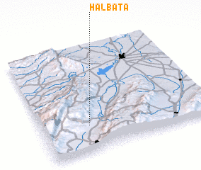 Places with similar names to Ḩalbatā, Lebanon ::
Disclaimer :: Information on this page comes without warranty of any kind |
||
|
Where is Ḩalbatā? Elevation and coordinates ::
Latitude (lat): 34°15'0"N Longitude (lon): 36°17'0"E
Elevation (approx.): 1257m (map arrows pan, magnifying glasses zoom) |
||
|
Visiting Ḩalbatā? Hotel/Accommodation ::
Book a hotel in Ḩalbatā Travel Guide ::
Buy a travel guide for Lebanon rental cars ::
car rental offers GPS waypoint ::
download a GPX waypoint (PoI) of Ḩalbatā for your GPS receiver
|
||