|
search place name
|
||
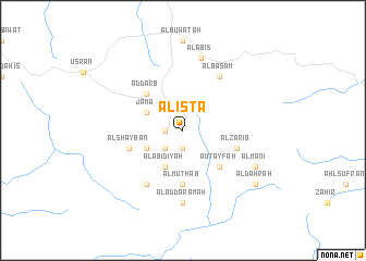
Alistā (Saudi Arabia)Alistā is a town in Saudi Arabia. An overview map of the region around Alistā is displayed below.
regional and 3d topo map of Alistā, Saudi Arabia ::
Alistā airports ::
The nearest airport is AHB - Abha, located 58.6 km north west of Alistā.
Other airports nearby include GIZ - Gizan King Abdullah Bin Abdulaziz (135.6 km south west), EAM - Nejran (141.3 km east), BHH - Bisha (226.6 km north), Nearby towns ::
Ashburmā (1.9km south) //
Āl Farḩān (1.8km west) //
Āl Harasā (2.6km south west) //
Āl aţ Ţafīlah (4.0km south west) //
Jāmā (4.0km north west) //
Al Wasaţ (4.1km south west) //
Al ‘Abīdīyah (4.1km south west) //
Ad Darb (5.1km north west) //
Ā ‘Uţayfah (5.1km south east) //
Az Zāwiyah (5.1km south east) //
Āl Muthāb (5.6km south) //
Āl Shaybān (5.6km west) //
Āl Zārib (5.6km east) //
Āl Khalaf (6.6km south west) //
Al Basām (6.6km north east) //
Āl ad Darāmah (7.4km south) //
Āl ‘Ābis (7.6km north) //
Al Māni‘ (8.0km south east) //
Āl Ḑahrah (9.0km south east) //
[all distances 'as the bird flies' and approximate] 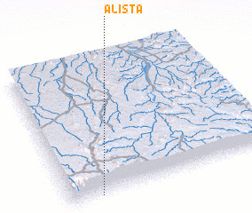 Places with similar names to Alistā, Saudi Arabia ::
Disclaimer :: Information on this page comes without warranty of any kind |
||
|
Where is Alistā? Elevation and coordinates ::
Latitude (lat): 18°0'0"N Longitude (lon): 43°9'0"E
Elevation (approx.): 2412m (map arrows pan, magnifying glasses zoom) |
||
|
Visiting Alistā? Hotel/Accommodation ::
Book a hotel in Alistā Travel Guide ::
rental cars ::
car rental offers GPS waypoint ::
download a GPX waypoint (PoI) of Alistā for your GPS receiver
|
||