|
search place name
|
||
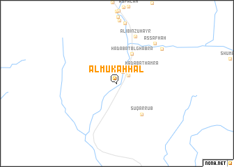
Al Mukaḩḩal (Saudi Arabia)Al Mukaḩḩal is a town in Saudi Arabia. An overview map of the region around Al Mukaḩḩal is displayed below.
regional and 3d topo map of Al Mukaḩḩal, Saudi Arabia ::
Al Mukaḩḩal airports ::
The nearest airport is ABT - El-baha Al Baha, located 115.8 km north of Al Mukaḩḩal.
Other airports nearby include BHH - Bisha (117.7 km north east), AHB - Abha (144.8 km south east), Nearby towns ::
Sūq ath Thulāthāʼ (2.0km north east) //
Qarn Hadhīl (2.1km north east) //
Ḩadabat Ḩamrāʼ (4.5km north east) //
Ḩadabat al Ghabrāʼ (5.2km north east) //
Sūq ar Rub‘ (6.2km south east) //
‘Ali Bin Zuhayr (8.0km north) //
Aş Şafḩah (8.6km north east) //
As Sarbah (8.8km north east) //
[all distances 'as the bird flies' and approximate]  Places with similar names to Al Mukaḩḩal, Saudi Arabia ::
// Al Miqallah (EG)
// Al Mukaylī (SA)
// Ālam Kili (PK)
// Almae-gol (KP)
// Al Maqla‘ (SY)
// Al Ma‘qul (OM)
// Al Ma‘qil (IQ)
// ‘Alam Kolā (IR)
// Al Ma‘qil (YE)
// Al Mukallā (YE)
Disclaimer :: Information on this page comes without warranty of any kind |
||
|
Where is Al Mukaḩḩal? Elevation and coordinates ::
Latitude (lat): 19°15'41"N Longitude (lon): 41°47'52"E
Elevation (approx.): 412m (map arrows pan, magnifying glasses zoom) |
||
|
Visiting Al Mukaḩḩal? Hotel/Accommodation ::
Book a hotel in Al Mukaḩḩal Travel Guide ::
rental cars ::
car rental offers GPS waypoint ::
download a GPX waypoint (PoI) of Al Mukaḩḩal for your GPS receiver
|
||