|
search place name
|
||
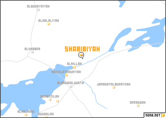
Shabībīyah (Saudi Arabia)Shabībīyah is a town in Saudi Arabia. An overview map of the region around Shabībīyah is displayed below.
regional and 3d topo map of Shabībīyah, Saudi Arabia ::
Shabībīyah airports ::
The nearest airport is ELQ - Gassim, located 28.1 km north of Shabībīyah.
Other airports nearby include HBT - King Khalid Mil.city King Khaled Military City (270.6 km north east), Nearby towns ::
Al Ḩillah (2.5km south west) //
Manzilat Ḩadrīyah (5.0km south west) //
Al Badāʼi‘ al Wusţá (6.7km south) //
Jaradat al Buraykah (9.1km south east) //
Al Halālīyah (10.5km north west) //
[all distances 'as the bird flies' and approximate]  Places with similar names to Shabībīyah, Saudi Arabia ::
// Shabūbīyah (SY)
Disclaimer :: Information on this page comes without warranty of any kind |
||
|
Where is Shabībīyah? Elevation and coordinates ::
Latitude (lat): 26°3'0"N Longitude (lon): 43°45'0"E
Elevation (approx.): 649m (map arrows pan, magnifying glasses zoom) |
||
|
Visiting Shabībīyah? Hotel/Accommodation ::
Book a hotel in Shabībīyah Travel Guide ::
rental cars ::
car rental offers GPS waypoint ::
download a GPX waypoint (PoI) of Shabībīyah for your GPS receiver
|
||