|
search place name
|
||
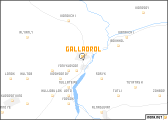
G‘allaorol (Jizzax, Uzbekistan)G‘allaorol is a town in the Jizzax region of Uzbekistan. An overview map of the region around G‘allaorol is displayed below.
regional and 3d topo map of G‘allaorol, Uzbekistan ::
G‘allaorol airports ::
The nearest airport is SKD - Samarkand, located 63.5 km south west of G‘allaorol.
Other airports nearby include DYU - Dushanbe (195.3 km south east), TAS - Tashkent Yuzhny (197.8 km north east), Nearby towns ::
Milyutinskaya (1.3km north) //
Voroshilov (1.3km north) //
Sarbazar (2.7km south west) //
Yany-Kurgan (3.5km south west) //
Sasyk (5.2km south east) //
Kosh-Saray (5.9km south west) //
Balgaly (5.9km south west) //
Mulla-Tepe (6.6km south west) //
Khanaka (6.0km south west) //
Bakhmalʼ (6.7km north east) //
Urta (8.4km south) //
Karakchi (9.1km north) //
Mullabulak (9.6km south west) //
Tutli (9.9km south east) //
[all distances 'as the bird flies' and approximate] 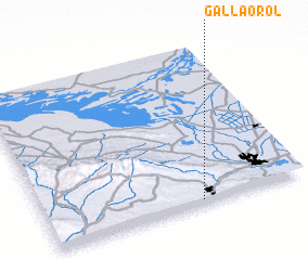 Places with similar names to G‘allaorol, Uzbekistan ::
// Collaralli (IT)
// Calarillo (ES)
// Gulorlau (TP)
// Calle Real (SV)
// Calerilla (MX)
// Calle Real (MX)
// Kolarel (SD)
// Galrole (NG)
// Kalriāla (PK)
// Caleruela (ES)
Disclaimer :: Information on this page comes without warranty of any kind |
||
|
Where is G‘allaorol? Elevation and coordinates ::
Latitude (lat): 40°1'17"N Longitude (lon): 67°35'51"E
Elevation (approx.): 571m (map arrows pan, magnifying glasses zoom) |
||
|
Visiting G‘allaorol? Hotel/Accommodation ::
Book a hotel in G‘allaorol Travel Guide ::
Buy a travel guide for Uzbekistan rental cars ::
car rental offers GPS waypoint ::
download a GPX waypoint (PoI) of G‘allaorol for your GPS receiver
|
||