|
search place name
|
||
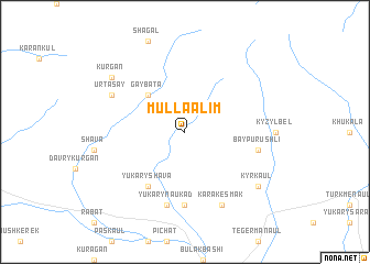
Mulla-Alim (Uzbekistan)Mulla-Alim is a town in Uzbekistan. An overview map of the region around Mulla-Alim is displayed below.
regional and 3d topo map of Mulla-Alim, Uzbekistan ::
Mulla-Alim airports ::
The nearest airport is SKD - Samarkand, located 82.0 km south of Mulla-Alim.
Nearby towns ::
Gay-Bata (4.7km north west) //
Yukary-Shava (6.2km south west) //
Naukad (7.4km south) //
Baypurushli (5.9km east) //
Yukary-Naukad (7.5km south) //
Kara-Kesmak (7.9km south) //
Urta-Say (6.8km north west) //
Kyrk-Aul (7.9km south east) //
Kurgan (7.9km north west) //
[all distances 'as the bird flies' and approximate] 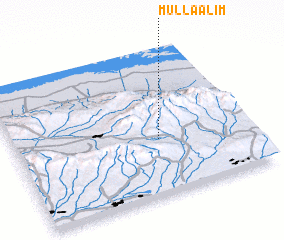 Places with similar names to Mulla-Alim, Uzbekistan ::
// Malalam (PH)
// Malalam (PH)
// Mololema (ZA)
// Malyye Lomy (RU)
// Malualumba (CD)
// Mulilima (ZM)
// Mululuma (ZM)
// Mululumi (ZM)
// Mulla Alām (PK)
// Malalamai (PG)
Disclaimer :: Information on this page comes without warranty of any kind |
||
|
Where is Mulla-Alim? Elevation and coordinates ::
Latitude (lat): 40°23'0"N Longitude (lon): 66°37'0"E
Elevation (approx.): 1154m (map arrows pan, magnifying glasses zoom) |
||
|
Visiting Mulla-Alim? Hotel/Accommodation ::
Book a hotel in Mulla-Alim Travel Guide ::
Buy a travel guide for Uzbekistan rental cars ::
car rental offers GPS waypoint ::
download a GPX waypoint (PoI) of Mulla-Alim for your GPS receiver
|
||