|
search place name
|
||
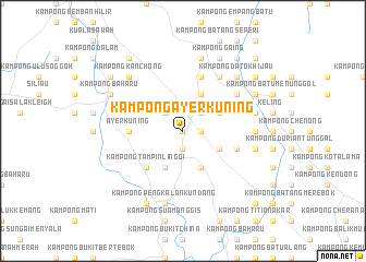
Kampong Ayer Kuning (Negeri Sembilan, Malaysia)Kampong Ayer Kuning is a town in the Negeri Sembilan region of Malaysia. An overview map of the region around Kampong Ayer Kuning is displayed below.
regional and 3d topo map of Kampong Ayer Kuning, Malaysia ::
Kampong Ayer Kuning airports ::
The nearest airport is MKZ - Malacca, located 39.9 km south east of Kampong Ayer Kuning.
Other airports nearby include KUL - Kuala Lumpur Intl (42.0 km north west), DUM - Dumai Pinang Kampai (123.6 km south west), KUA - Kuantan (188.2 km north east), JHB - Johor Bahru Sultan Ismail (207.9 km south east), Nearby towns ::
Kampong Solok Ayer Kuning (0.0km north) //
Kampong Kundor Tengah (1.9km south) //
Kampong Solok Ayer Murai (1.9km east) //
Kampong Kundor Ulu (2.6km north west) //
Kampong Merbau Sembilan (2.6km north east) //
Kampong Serdang (2.6km north east) //
Kampong Tampin Kanan (4.1km south west) //
Kampong Pilin Hilir (4.1km south east) //
Kampong Kundor Hilir (4.1km south east) //
Kampong Paya Lebar (4.1km south east) //
Kampong Sungai Ibor (4.1km north east) //
Kampong Pedas Hilir (4.1km north east) //
Kampong Paya Besar (4.1km north east) //
Kampong Sungai Dua (4.1km north east) //
Kampong Pilin (4.1km south east) //
Kampong Miching (4.1km north east) //
Kampong Solok Mempatah (4.1km north east) //
Kampong Tampin Linggi (5.2km south west) //
Kampong Tampin Kiri (5.2km south west) //
Ayer Kuning (5.6km west) //
Kampong Sungai Batu (5.9km north) //
Kampong Pedas Gedang (5.9km north) //
Kampong Durian Daun (5.9km east) //
Kampong Simpang Keling (5.9km east) //
Kampong Seberang Batu Hampar (6.7km north east) //
Kampong Terentang (6.7km north east) //
Kampong Tanjong Sena (6.7km north east) //
Kampong Anak Ayer Kundor (6.7km north east) //
Kampong Bukit (7.4km east) //
[all distances 'as the bird flies' and approximate] 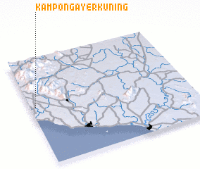 Places with similar names to Kampong Ayer Kuning, Malaysia ::
Disclaimer :: Information on this page comes without warranty of any kind |
||
|
Where is Kampong Ayer Kuning? Elevation and coordinates ::
Latitude (lat): 2°33'0"N Longitude (lon): 102°2'0"E
Elevation (approx.): 67m (map arrows pan, magnifying glasses zoom) |
||
|
Visiting Kampong Ayer Kuning? Hotel/Accommodation ::
Book a hotel in Kampong Ayer Kuning Travel Guide ::
Buy a travel guide for Malaysia rental cars ::
car rental offers GPS waypoint ::
download a GPX waypoint (PoI) of Kampong Ayer Kuning for your GPS receiver
|
||