|
search place name
|
||
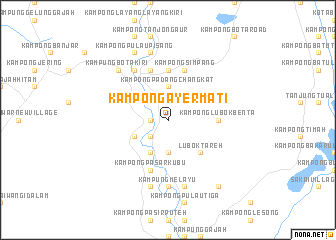
Kampong Ayer Mati (Perak, Malaysia)Kampong Ayer Mati is a town in the Perak region of Malaysia. An overview map of the region around Kampong Ayer Mati is displayed below.
regional and 3d topo map of Kampong Ayer Mati, Malaysia ::
Kampong Ayer Mati airports ::
The nearest airport is IPH - Ipoh Sultan Azlan Shah, located 35.5 km north east of Kampong Ayer Mati.
Other airports nearby include PEN - Penang Intl (131.1 km north west), KUL - Kuala Lumpur Intl (193.2 km south east), AOR - Alor Setar Sultan Abdul Halim (216.7 km north), KBR - Kota Bahru Sultan Ismail Petra (256.7 km north east), Nearby towns ::
Kampong Pulau Kuchai (1.8km west) //
Kampong Suak Padi (2.6km north east) //
Temboh Hangar (2.6km north east) //
Kampong Tua (2.6km south west) //
Kampong Sedingka (2.6km north west) //
Kampong Tanjong Perdayong (3.7km south) //
Kampong Talang (3.7km south) //
Kampong Padang Changkat (3.7km north) //
Kampung Lambur Kanan (4.1km south west) //
Kampung Lambur Kiri (4.1km south west) //
Kampong Tanjong (4.1km south west) //
Kampong Telok Bakong (4.1km south west) //
Kampong Telok Kepayang (4.1km north west) //
Lubok Tareh (5.2km south east) //
Kampong Changkat Panchor (5.6km north) //
Kampong Lubok Benta (5.5km east) //
Kampong Simpang (5.9km north) //
Kampong Durian Kudong (5.9km north) //
Kampong Pasar Kubu (5.9km south) //
Kampong Kubang Chandong (5.9km north) //
Kampung Bota Kanan (6.7km north west) //
Kampong Telok Sareh (7.4km south) //
Kampung Melayu (7.4km south) //
Kampong Melayu (7.6km south) //
Kampong Pasir Garam (7.6km south) //
Kampong Pulau Padang (7.6km north) //
Asam Kumbang (7.6km south) //
Kampong Padang Tenggala (7.6km north) //
Kampung Bota Kiri (7.9km north west) //
[all distances 'as the bird flies' and approximate] 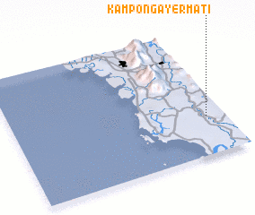 Places with similar names to Kampong Ayer Mati, Malaysia ::
// Kampong Ayer Mati (MY)
// Kampong Ayer Mati (MY)
Disclaimer :: Information on this page comes without warranty of any kind |
||
|
Where is Kampong Ayer Mati? Elevation and coordinates ::
Latitude (lat): 4°18'0"N Longitude (lon): 100°55'0"E
Elevation (approx.): 17m (map arrows pan, magnifying glasses zoom) |
||
|
Visiting Kampong Ayer Mati? Hotel/Accommodation ::
Book a hotel in Kampong Ayer Mati Travel Guide ::
Buy a travel guide for Malaysia rental cars ::
car rental offers GPS waypoint ::
download a GPX waypoint (PoI) of Kampong Ayer Mati for your GPS receiver
|
||