|
search place name
|
||
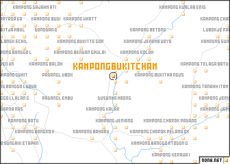
Kampong Bukit Cham (Kedah, Malaysia)Kampong Bukit Cham is a town in the Kedah region of Malaysia. An overview map of the region around Kampong Bukit Cham is displayed below.
regional and 3d topo map of Kampong Bukit Cham, Malaysia ::
Kampong Bukit Cham airports ::
The nearest airport is AOR - Alor Setar Sultan Abdul Halim, located 42.7 km north west of Kampong Bukit Cham.
Other airports nearby include PEN - Penang Intl (75.9 km south west), LGK - Pulau Langkawi Intl (111.6 km north west), PAN - Pattani (115.2 km north east), HDY - Songkhla Hat Yai Intl (119.1 km north), Nearby towns ::
Kampong Tala (0.0km north) //
Kampong Kota Bukit (0.0km north) //
Kampong Langgol (0.0km north) //
Kampong Kuala Reman (1.9km south) //
Kampong Kuala Berok (1.9km north) //
Kampong Gajah Puteh (1.9km north) //
Kampong Tanjong (1.8km east) //
Kampung Jeneri (1.8km east) //
Kampong Mus (2.6km north east) //
Kampong Batas Keling (2.6km north east) //
Kampong Kuala Temin (2.6km north east) //
Dusun Mambong (3.7km south) //
Kampong Pengkalan Raja (4.1km north east) //
Kampong Parit (4.1km north east) //
Kampong Tok Aris (4.1km north east) //
Dusun Pengapit (4.1km north east) //
Kampong Sidu (5.2km north east) //
Kampong Kolam (5.2km north east) //
Kampong Beruna (5.9km south) //
Kampong Kalar (5.9km south) //
Kampong Whatt (5.8km east) //
Kampong Banggoi (5.8km east) //
Kampong Padang Pulut (6.7km north east) //
Kampong Bendang Pulai (6.7km north west) //
Jeniang (7.4km south) //
Kampong Jeniang (7.4km south) //
Kampong Bukit Minyak (7.4km south) //
Kampong Bukit Hangus (7.4km east) //
Kampong Lubok Gading (7.6km south) //
[all distances 'as the bird flies' and approximate]  Places with similar names to Kampong Bukit Cham, Malaysia :: Disclaimer :: Information on this page comes without warranty of any kind |
||
|
Where is Kampong Bukit Cham? Elevation and coordinates ::
Latitude (lat): 5°53'0"N Longitude (lon): 100°38'0"E
Elevation (approx.): 42m (map arrows pan, magnifying glasses zoom) |
||
|
Visiting Kampong Bukit Cham? Hotel/Accommodation ::
Book a hotel in Kampong Bukit Cham Travel Guide ::
Buy a travel guide for Malaysia rental cars ::
car rental offers GPS waypoint ::
download a GPX waypoint (PoI) of Kampong Bukit Cham for your GPS receiver
|
||