|
search place name
|
||
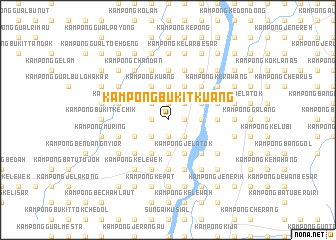
Kampong Bukit Kuang (Kelantan, Malaysia)Kampong Bukit Kuang is a town in the Kelantan region of Malaysia. An overview map of the region around Kampong Bukit Kuang is displayed below.
regional and 3d topo map of Kampong Bukit Kuang, Malaysia ::
Kampong Bukit Kuang airports ::
The nearest airport is KBR - Kota Bahru Sultan Ismail Petra, located 36.8 km north east of Kampong Bukit Kuang.
Other airports nearby include NAW - Narathiwat (85.1 km north west), TGG - Kuala Terengganu Sultan Mahmud (118.4 km south east), PAN - Pattani (149.9 km north west), IPH - Ipoh Sultan Azlan Shah (185.4 km south west), Nearby towns ::
Kampong Hutan Bentangor (1.9km north) //
Kampong Kubang Kerian (1.9km north) //
Kampong Dusun Pulai (1.8km east) //
Kampong Dumis (1.8km east) //
Kampong Salak (1.8km east) //
Kampong Batu Garum (1.9km south) //
Kampong Tandak (1.9km south) //
Kampong Bukit Gading (1.8km west) //
Kampong Paloh (2.6km north east) //
Kampong Darat (2.6km north east) //
Bukit Panau (2.6km north east) //
Kampong Tengah (2.6km north east) //
Kampong Chabang Empat (2.6km north east) //
Kampung Bukit Mas (2.6km north west) //
Dusun Mok Mor (2.6km south east) //
Kampong Belimbing (2.6km south east) //
Kampong Hutan Teja (2.6km south west) //
Kampong Bagan (3.7km east) //
Kampong Mata Ayer (3.7km east) //
Kampong Binjai Manis (3.7km north) //
Kampong Berchang (3.7km north) //
Kampong Chap Rimau (3.7km south) //
Kampong Padang Siam (3.7km south) //
Kampong Kubang Tebik (4.1km north east) //
Kampong Sungai Dulang (4.1km north east) //
Kampong Hutan Gogong (4.1km north east) //
Kampong Cherang Jelor (4.1km north east) //
Kampong Tandak (4.1km north east) //
Kampong Hutan Petai (4.1km north east) //
[all distances 'as the bird flies' and approximate]  Places with similar names to Kampong Bukit Kuang, Malaysia ::
Disclaimer :: Information on this page comes without warranty of any kind |
||
|
Where is Kampong Bukit Kuang? Elevation and coordinates ::
Latitude (lat): 5°52'0"N Longitude (lon): 102°9'0"E
Elevation (approx.): 21m (map arrows pan, magnifying glasses zoom) |
||
|
Visiting Kampong Bukit Kuang? Hotel/Accommodation ::
Book a hotel in Kampong Bukit Kuang Travel Guide ::
Buy a travel guide for Malaysia rental cars ::
car rental offers GPS waypoint ::
download a GPX waypoint (PoI) of Kampong Bukit Kuang for your GPS receiver
|
||