|
search place name
|
||
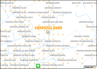
Kampong Lahar (Kedah, Malaysia)Kampong Lahar is a town in the Kedah region of Malaysia. An overview map of the region around Kampong Lahar is displayed below.
regional and 3d topo map of Kampong Lahar, Malaysia ::
Kampong Lahar airports ::
The nearest airport is AOR - Alor Setar Sultan Abdul Halim, located 12.8 km south of Kampong Lahar.
Other airports nearby include HDY - Songkhla Hat Yai Intl (70.2 km north), LGK - Pulau Langkawi Intl (78.0 km west), PAN - Pattani (96.1 km north east), PEN - Penang Intl (112.2 km south), Nearby towns ::
Kampong Pahna (0.0km north) //
Kampong Lubok Ipoh (1.9km south) //
Kampong Biak (1.9km south) //
Kampong Bata (1.9km south) //
Kampong Pina (1.8km east) //
Kampong Perupok (1.8km east) //
Kampong Asun (2.6km north west) //
Kampong Kubu (2.6km north east) //
Kampong Penia (2.6km south east) //
Kampong Tualang Lama (2.6km north east) //
Kampong Palas (2.6km north east) //
Tualang Baharu (2.6km north east) //
Kampong Malau (2.6km south east) //
Kampong Gelong (3.7km west) //
Kampong Mambang (3.7km west) //
Kampong Hutan Kering (3.7km west) //
Kampong Belukar (3.7km west) //
Kampong Binjal (3.7km north) //
Kampong Titi Panjang (3.7km north) //
Kampong Padang Panjang (3.7km east) //
Kubang Lembu (4.1km south west) //
Kampong Padang (4.1km south west) //
Jitra (4.1km south west) //
Kampong Telok Ara (4.1km south west) //
Kampong Manggoi (4.1km south west) //
Kampong Salit (4.1km north west) //
Kampong Telok Berangan (4.1km south west) //
Kampong Pulau Ketam (4.1km south west) //
Kampong Bukit Beruas (4.1km north east) //
[all distances 'as the bird flies' and approximate]  Places with similar names to Kampong Lahar, Malaysia ::
// Kampong Lahar (MY)
// Kampong Lahar (MY)
Disclaimer :: Information on this page comes without warranty of any kind |
||
|
Where is Kampong Lahar? Elevation and coordinates ::
Latitude (lat): 6°18'0"N Longitude (lon): 100°26'0"E
Elevation (approx.): 17m (map arrows pan, magnifying glasses zoom) |
||
|
Visiting Kampong Lahar? Hotel/Accommodation ::
Book a hotel in Kampong Lahar Travel Guide ::
Buy a travel guide for Malaysia rental cars ::
car rental offers GPS waypoint ::
download a GPX waypoint (PoI) of Kampong Lahar for your GPS receiver
|
||