|
search place name
|
||
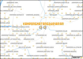
Kampong Matang Durian (Kedah, Malaysia)Kampong Matang Durian is a town in the Kedah region of Malaysia. An overview map of the region around Kampong Matang Durian is displayed below.
regional and 3d topo map of Kampong Matang Durian, Malaysia ::
Kampong Matang Durian airports ::
The nearest airport is PEN - Penang Intl, located 46.9 km south west of Kampong Matang Durian.
Other airports nearby include AOR - Alor Setar Sultan Abdul Halim (74.8 km north), IPH - Ipoh Sultan Azlan Shah (120.7 km south east), LGK - Pulau Langkawi Intl (130.8 km north west), PAN - Pattani (149.0 km north east), Nearby towns ::
Kampong Matang Durian (1.8km east) //
Kampong Tanah Lichin (1.9km north) //
Kampong Lubok Kiab (1.8km west) //
Kampong Kuala Sedim (1.8km west) //
Merbau Pulas (2.6km north east) //
Kampong Sebarang (2.6km north east) //
Telok Sira (2.6km south west) //
Titi Karangan (3.7km south) //
Lahar Kemumbong (3.7km west) //
Kampong Manggol (3.7km west) //
Kampong Kemumbong (3.7km west) //
Kampong Kuala Kuli (4.1km north east) //
Kampong Lesong Tujoh (4.1km south west) //
Kampong Padang Meligai (5.5km west) //
Kampong Tengah (5.5km west) //
Kampong Pantai Chichak (5.6km north) //
Kampong Padang Meha (5.6km south) //
Tanjong Peteri (5.9km north) //
Kampong Lubok Machang (5.8km east) //
Kampong Pantai Idau (5.8km west) //
Kampong Sidam (5.8km west) //
Kampong Sidam Kanan (5.8km west) //
Kuala Ketil (6.7km north east) //
Kampong Jerong (6.7km north west) //
Kampong Lubok Saga (7.4km west) //
Kampong Banggol Besi (7.4km west) //
Kampong Padang Buloh (7.4km west) //
Kampong Kubang Sapi (7.4km west) //
Kampong Siam (7.4km south) //
[all distances 'as the bird flies' and approximate]  Places with similar names to Kampong Matang Durian, Malaysia ::
// Kampong Matang Durian (MY)
Disclaimer :: Information on this page comes without warranty of any kind |
||
|
Where is Kampong Matang Durian? Elevation and coordinates ::
Latitude (lat): 5°33'0"N Longitude (lon): 100°37'0"E
Elevation (approx.): 11m (map arrows pan, magnifying glasses zoom) |
||
|
Visiting Kampong Matang Durian? Hotel/Accommodation ::
Book a hotel in Kampong Matang Durian Travel Guide ::
Buy a travel guide for Malaysia rental cars ::
car rental offers GPS waypoint ::
download a GPX waypoint (PoI) of Kampong Matang Durian for your GPS receiver
|
||