|
search place name
|
||
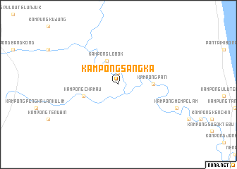
Kampong Sangka (Pahang, Malaysia)Kampong Sangka is a town in the Pahang region of Malaysia. An overview map of the region around Kampong Sangka is displayed below.
regional and 3d topo map of Kampong Sangka, Malaysia ::
Kampong Sangka airports ::
The nearest airport is KUA - Kuantan, located 60.5 km north of Kampong Sangka.
Other airports nearby include KTE - Kerteh (145.1 km north), MKZ - Malacca (157.1 km south west), JHB - Johor Bahru Sultan Ismail (181.2 km south), KUL - Kuala Lumpur Intl (183.0 km west), Nearby towns ::
Kampong Kedondong (1.9km north) //
Kampong Lobok (4.1km north west) //
Kampong Pati (5.6km east) //
Kampong Tanah Hangus (5.9km west) //
Kampong Chamau (5.9km west) //
[all distances 'as the bird flies' and approximate] 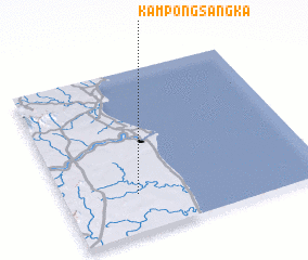 Places with similar names to Kampong Sangka, Malaysia ::
// Kampong Sungkai (MY)
Disclaimer :: Information on this page comes without warranty of any kind |
||
|
Where is Kampong Sangka? Elevation and coordinates ::
Latitude (lat): 3°14'0"N Longitude (lon): 103°17'0"E
Elevation (approx.): 7m (map arrows pan, magnifying glasses zoom) |
||
|
Visiting Kampong Sangka? Hotel/Accommodation ::
Book a hotel in Kampong Sangka Travel Guide ::
Buy a travel guide for Malaysia rental cars ::
car rental offers GPS waypoint ::
download a GPX waypoint (PoI) of Kampong Sangka for your GPS receiver
|
||