|
search place name
|
||
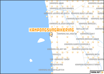
Kampong Sungai Kering (Kedah, Malaysia)Kampong Sungai Kering is a town in the Kedah region of Malaysia. An overview map of the region around Kampong Sungai Kering is displayed below.
regional and 3d topo map of Kampong Sungai Kering, Malaysia ::
Kampong Sungai Kering airports ::
The nearest airport is AOR - Alor Setar Sultan Abdul Halim, located 34.1 km north of Kampong Sungai Kering.
Other airports nearby include PEN - Penang Intl (65.6 km south), LGK - Pulau Langkawi Intl (86.2 km north west), HDY - Songkhla Hat Yai Intl (116.1 km north), PAN - Pattani (132.4 km north east), Nearby towns ::
Kampong Sedaka Kechil (1.9km south) //
Kampong Sungai Bujar (1.8km east) //
Kampong Sungai Lintang (1.8km east) //
Kampong Sungai Ayer Hitam (1.9km north) //
Kampong Kuala Sungai Limau (1.9km north) //
Kampong Sungai Tongkang (1.9km north) //
Sungai Limau (1.9km north) //
Kampong Masjid Jawa (2.6km south east) //
Kampong Kuala Sedaka (2.6km south east) //
Kampong Telok Tawar (2.6km north east) //
Simpang Empat (2.6km north east) //
Kampong Kabu Sepuloh (2.6km north east) //
Kampong Sematang Kechil (3.7km north) //
Kampong Kuala Sungai Duan (3.7km north) //
Kampong Pisang (3.7km north) //
Kampong Sungai Dedap (3.7km north) //
Kampong Dulang Kechil (4.1km south east) //
Kampong Sungai Daun Tengah (4.1km north east) //
Kampong Pulau Tembun (5.2km north east) //
Kampong Ulu Sungai Daun (5.2km north east) //
Kampong Selingkoh (5.5km east) //
Kampong Sedaka Tengan (5.5km east) //
Kampong Ulu Sedaka (5.8km east) //
Kampong Lat Anam (5.9km north) //
Kampong Kelantan (5.9km south) //
Kampong Dulang Besar (5.9km south) //
Kampong Yan Kechil (5.9km south) //
Kampong Batu (6.7km south east) //
Kampong Sungai Dulang Tengah (6.7km south east) //
[all distances 'as the bird flies' and approximate]  Places with similar names to Kampong Sungai Kering, Malaysia ::
Disclaimer :: Information on this page comes without warranty of any kind |
||
|
Where is Kampong Sungai Kering? Elevation and coordinates ::
Latitude (lat): 5°53'0"N Longitude (lon): 100°22'0"E
Elevation (approx.): 3m (map arrows pan, magnifying glasses zoom) |
||
|
Visiting Kampong Sungai Kering? Hotel/Accommodation ::
Book a hotel in Kampong Sungai Kering Travel Guide ::
Buy a travel guide for Malaysia rental cars ::
car rental offers GPS waypoint ::
download a GPX waypoint (PoI) of Kampong Sungai Kering for your GPS receiver
|
||