|
search place name
|
||
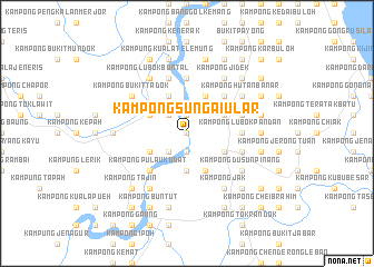
Kampong Sungai Ular (Terengganu, Malaysia)Kampong Sungai Ular is a town in the Terengganu region of Malaysia. An overview map of the region around Kampong Sungai Ular is displayed below.
regional and 3d topo map of Kampong Sungai Ular, Malaysia ::
Kampong Sungai Ular airports ::
The nearest airport is TGG - Kuala Terengganu Sultan Mahmud, located 26.4 km north of Kampong Sungai Ular.
Other airports nearby include KTE - Kerteh (79.6 km south east), KBR - Kota Bahru Sultan Ismail Petra (140.3 km north west), KUA - Kuantan (153.0 km south), NAW - Narathiwat (209.5 km north west), Nearby towns ::
Kampong Tapu (0.0km north) //
Kampong Tanggol (1.9km south) //
Kampong Kenanga (1.9km north) //
Kampong Binjai Kertas (2.6km south west) //
Kampong Kuala Kejer (2.6km south west) //
Kampong Nasi Dingin (2.6km north west) //
Kampong Bukit Kabong (3.7km south) //
Kampong Kuala Akot (4.1km south west) //
Kampong Paloh Nyior (4.1km north west) //
Kampong Getang Ulu (4.1km north west) //
Kampong Kubang Burong (4.1km north east) //
Kampong Getang Hilir (4.1km north west) //
Kampong Pak Bilis (4.1km south east) //
Kampong Lubok Perah (4.1km south east) //
Kampong Cherang China (4.1km north east) //
Kampong Kayu Arang (4.1km south east) //
Kampong Tapak Chator (4.1km north east) //
Kampong Pulau Kudat (5.2km south west) //
Kampong Durian Guling (5.2km north east) //
Kampong Lubok Pandan (5.5km east) //
Kampong Kuala Bekah (5.5km east) //
Kampong Tanjong Aur (5.6km north) //
Kampong Nyut Nyut (5.6km north) //
Wakaf Tapai (5.8km east) //
Kampong Batu Penunggol (5.8km east) //
Kampong Chepoh (5.9km north) //
Kampong Lubok Buntal (6.7km north west) //
Kampong Hutan Banar (6.7km north east) //
Kampong Bukit Sawa (6.7km north east) //
[all distances 'as the bird flies' and approximate] 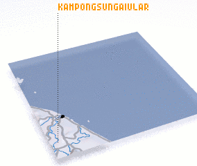 Places with similar names to Kampong Sungai Ular, Malaysia ::
// Kampong Sungai Lar (MY)
// Kampong Sungai Ular (MY)
// Kampong Sungai Ular (MY)
// Kampung Sungai Ular (MY)
// Kampung Sungai Ular (MY)
// Kampung Sungai Ular (MY)
Disclaimer :: Information on this page comes without warranty of any kind |
||
|
Where is Kampong Sungai Ular? Elevation and coordinates ::
Latitude (lat): 5°9'0"N Longitude (lon): 103°3'0"E
Elevation (approx.): 15m (map arrows pan, magnifying glasses zoom) |
||
|
Visiting Kampong Sungai Ular? Hotel/Accommodation ::
Book a hotel in Kampong Sungai Ular Travel Guide ::
Buy a travel guide for Malaysia rental cars ::
car rental offers GPS waypoint ::
download a GPX waypoint (PoI) of Kampong Sungai Ular for your GPS receiver
|
||