|
search place name
|
||
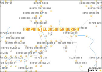
Kampong Telok Sungai Durian (Kedah, Malaysia)Kampong Telok Sungai Durian is a town in the Kedah region of Malaysia. An overview map of the region around Kampong Telok Sungai Durian is displayed below.
regional and 3d topo map of Kampong Telok Sungai Durian, Malaysia ::
Kampong Telok Sungai Durian airports ::
The nearest airport is AOR - Alor Setar Sultan Abdul Halim, located 79.0 km north west of Kampong Telok Sungai Durian.
Other airports nearby include PEN - Penang Intl (86.3 km south west), PAN - Pattani (120.7 km north), NAW - Narathiwat (126.2 km north east), IPH - Ipoh Sultan Azlan Shah (128.2 km south), Nearby towns ::
Kampong Lahar (1.8km west) //
Kampong Banggol Sentol (1.8km west) //
Kampong Banggol (1.9km south) //
Kampong Batu Bungor (2.6km south west) //
Kampong Bakar Bata (2.6km south west) //
Kampong Toh Tih (2.6km south west) //
Kampong Padang Temu (2.6km south west) //
Kampong Bongor Tiga (2.6km south west) //
Kampong Nering (2.6km south west) //
Kampong Telok Kangar (2.6km south west) //
Kampong Jeral (2.6km south west) //
Kampong Masjid (2.6km south west) //
Kampong Banggol Pompong (2.6km south east) //
Kampong Rambong (2.6km south east) //
Kampong Banggol Leban (3.7km west) //
Kampong Pandai Saad (3.7km west) //
Kampong Telok Temelah (3.7km north) //
Kampong Kubu Tanah (3.7km south) //
Kampong Simpang Ampat (3.7km south) //
Kampong Seberang Wat (3.7km south) //
Kampong Bukit Payong (4.1km north west) //
Kampong Tanjong Paus (4.1km north west) //
Kampong Bendang Darat (4.1km north west) //
Kampong Tandok (4.1km north west) //
Kampong Dusun Gani (4.1km north west) //
Kampong Bawah Gunong (4.1km south west) //
Kampong Sungai Batu (4.1km south west) //
Kampong Pantai (4.1km south west) //
Kampong Seberang Pekan (4.1km south west) //
[all distances 'as the bird flies' and approximate]  Places with similar names to Kampong Telok Sungai Durian, Malaysia ::
// Kampong Telok Sengat (MY)
Disclaimer :: Information on this page comes without warranty of any kind |
||
|
Where is Kampong Telok Sungai Durian? Elevation and coordinates ::
Latitude (lat): 5°43'0"N Longitude (lon): 100°56'0"E
Elevation (approx.): 141m (map arrows pan, magnifying glasses zoom) |
||
|
Visiting Kampong Telok Sungai Durian? Hotel/Accommodation ::
Book a hotel in Kampong Telok Sungai Durian Travel Guide ::
Buy a travel guide for Malaysia rental cars ::
car rental offers GPS waypoint ::
download a GPX waypoint (PoI) of Kampong Telok Sungai Durian for your GPS receiver
|
||