|
search place name
|
||
Kampong Terang (Pulau Pinang, Malaysia)Kampong Terang is a town in the Pulau Pinang region of Malaysia. An overview map of the region around Kampong Terang is displayed below.
regional and 3d topo map of Kampong Terang, Malaysia ::

Kampong Terang airports ::
The nearest airport is PEN - Penang Intl, located 7.0 km east of Kampong Terang.
Other airports nearby include AOR - Alor Setar Sultan Abdul Halim (98.6 km north), LGK - Pulau Langkawi Intl (124.4 km north west), IPH - Ipoh Sultan Azlan Shah (127.6 km south east), HDY - Songkhla Hat Yai Intl (179.8 km north), Nearby towns ::
Genting (1.9km north) //
Simpang Ampat (1.9km north) //
Kampong Shee Tan (1.9km north) //
Kampong Paya (1.9km north) //
Kampong Enam (1.8km west) //
Kampong Perlis (1.8km west) //
Kampong Pondok Upeh (2.6km north east) //
Kampong Setul (2.6km north east) //
Kampong Tengah (2.6km south east) //
Kampong Matahari Jatoh (2.6km south east) //
Kampong Masjid (2.6km south east) //
Kampong Sungai Burong (2.6km north west) //
Kampong Enam (2.6km north west) //
Kampong Long Tambang (2.6km south west) //
PulauBetong (2.6km south west) //
Kampong Bakar Kapor (2.6km south west) //
Bagan Pulau Betung (2.6km south west) //
Telok Kumbar (3.2km south) //
Kampong Permatang Tengah (3.7km north) //
Kampong Paya Kongsi (3.7km north) //
Kampong Jalan Baharu (3.7km north) //
Kampong Kafri (4.1km north east) //
Ayer Puteh (4.1km north east) //
Kampong Titi Serong (4.1km north east) //
Kampong Permatang Timbun (4.1km north east) //
Balik Pulau (4.1km north east) //
Permatang Timbun (4.1km north east) //
Kampong Seronok (4.1km south east) //
Utan Nibong (4.1km south east) //
[all distances 'as the bird flies' and approximate] 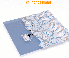 Places with similar names to Kampong Terang, Malaysia ::
// Kampong Taarong (MY)
// Kampong Teriang (MY)
// Kampong Tering (MY)
// Kampong Terong (MY)
// Kampong Terong (MY)
// Kampong Turong (MY)
// Kampong Derang (MY)
Disclaimer :: Information on this page comes without warranty of any kind |
||
|
Where is Kampong Terang? Elevation and coordinates ::
Latitude (lat): 5°19'0"N Longitude (lon): 100°13'0"E
Elevation (approx.): 18m (map arrows pan, magnifying glasses zoom) |
||
|
Visiting Kampong Terang? Hotel/Accommodation ::
Book a hotel in Kampong Terang Travel Guide ::
Buy a travel guide for Malaysia rental cars ::
car rental offers GPS waypoint ::
download a GPX waypoint (PoI) of Kampong Terang for your GPS receiver
|
||