|
search place name
|
||
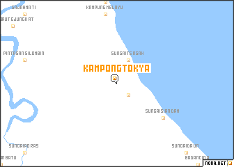
Kampong Tok Ya (Kedah, Malaysia)Kampong Tok Ya is a town in the Kedah region of Malaysia. An overview map of the region around Kampong Tok Ya is displayed below.
regional and 3d topo map of Kampong Tok Ya, Malaysia ::
Kampong Tok Ya airports ::
The nearest airport is DUM - Dumai Pinang Kampai, located 142.2 km south east of Kampong Tok Ya.
Other airports nearby include KUL - Kuala Lumpur Intl (156.7 km east), MKZ - Malacca (209.7 km east), MES - Medan Polonia (233.1 km north west), PKU - Pekanbaru Sultan Syarif Kasim Ii (237.7 km south east), Nearby towns ::
Sungaisiakap (2.6km south east) //
Sungaitengah (4.1km north east) //
Sungaisiandam (9.3km south east) //
[all distances 'as the bird flies' and approximate] 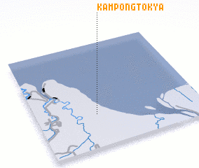 Places with similar names to Kampong Tok Ya, Malaysia ::
Disclaimer :: Information on this page comes without warranty of any kind |
||
|
Where is Kampong Tok Ya? Elevation and coordinates ::
Latitude (lat): 2°19'0"N Longitude (lon): 100°22'0"E
Elevation (approx.): 22m (map arrows pan, magnifying glasses zoom) |
||
|
Visiting Kampong Tok Ya? Hotel/Accommodation ::
Book a hotel in Kampong Tok Ya Travel Guide ::
Buy a travel guide for Malaysia rental cars ::
car rental offers GPS waypoint ::
download a GPX waypoint (PoI) of Kampong Tok Ya for your GPS receiver
|
||