|
search place name
|
||
Kampung Behrang (Perak, Malaysia)Kampung Behrang is a town in the Perak region of Malaysia. An overview map of the region around Kampung Behrang is displayed below.
regional and 3d topo map of Kampung Behrang, Malaysia ::

Kampung Behrang airports ::
The nearest airport is IPH - Ipoh Sultan Azlan Shah, located 98.8 km north west of Kampung Behrang.
Other airports nearby include KUL - Kuala Lumpur Intl (114.8 km south), MKZ - Malacca (187.0 km south east), KUA - Kuantan (195.4 km east), PEN - Penang Intl (215.0 km north west), Nearby towns ::
Kampong Selisik (1.9km south) //
Kampong Telok Raja (4.1km south east) //
Kampong Kelawar (5.2km south east) //
Kampong Batu Lima (5.5km east) //
Gedangsa (5.8km west) //
Kampong Kuala Keteyong (6.7km south east) //
Kampong Sungai Darau (6.7km north east) //
Behrang Hulu (6.7km north east) //
Kampong Balun (7.6km north) //
Kampong Lubok Salak (7.9km south east) //
Kampung Sungai Bil (9.3km north east) //
Kampong Keteyong (9.3km south east) //
Sakai Settlement (9.3km north west) //
Tanjung Malim (10.5km south east) //
TanjongMalim (10.5km south east) //
[all distances 'as the bird flies' and approximate] 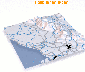 Places with similar names to Kampung Behrang, Malaysia ::
// Kampung Burong (MY)
// Kampong Baring (MY)
// Kampong Barong (MY)
// Kampong Biring (MY)
// Kampong Boring (MY)
// Kampong Burong (MY)
// Kampong Burong (MY)
Disclaimer :: Information on this page comes without warranty of any kind |
||
|
Where is Kampung Behrang? Elevation and coordinates ::
Latitude (lat): 3°45'0"N Longitude (lon): 101°27'0"E
Elevation (approx.): 41m (map arrows pan, magnifying glasses zoom) |
||
|
Visiting Kampung Behrang? Hotel/Accommodation ::
Book a hotel in Kampung Behrang Travel Guide ::
Buy a travel guide for Malaysia rental cars ::
car rental offers GPS waypoint ::
download a GPX waypoint (PoI) of Kampung Behrang for your GPS receiver
|
||