|
search place name
|
||
Kampung Jeram (Kelantan, Malaysia)Kampung Jeram is a town in the Kelantan region of Malaysia. An overview map of the region around Kampung Jeram is displayed below.
regional and 3d topo map of Kampung Jeram, Malaysia ::

Kampung Jeram airports ::
The nearest airport is KBR - Kota Bahru Sultan Ismail Petra, located 41.4 km north of Kampung Jeram.
Other airports nearby include TGG - Kuala Terengganu Sultan Mahmud (93.8 km south east), NAW - Narathiwat (105.3 km north west), PAN - Pattani (172.9 km north west), KTE - Kerteh (182.5 km south east), Nearby towns ::
Kampong Jebak (0.0km north) //
Kampong Lembah (1.8km east) //
Kampong Wakaf Tuku (1.8km east) //
Kampong Petani (1.8km east) //
Kampong Pengkalan Pauh (1.8km east) //
Kampong Taweh (1.9km south) //
Kampong Batu Berendam (1.9km south) //
Kampong Telipok (1.9km south) //
Kampong Telosan (1.9km south) //
Kampong Saring (2.6km north east) //
Kampong Chengal Batu (2.6km north east) //
Kampong Gong Garu (2.6km south east) //
Kampong Chengal Pulas (2.6km south west) //
Kampong Bonggol (2.6km south west) //
Kampong Cherang Tuli (3.7km north) //
Kampong Lepan Rambai (3.7km south) //
Kampong Bukit (3.7km south) //
Kampong Batas Besar (3.7km east) //
Kampong Kemal (3.7km east) //
Kampong Alor Pasir (4.1km north east) //
Kampong Wakaf Berangan (4.1km north east) //
Kampong Teratak Batu (4.1km south west) //
Kampong Panggong (4.1km north west) //
Kampong Gong Genor (4.1km south west) //
Kampong Changgai (4.1km south east) //
Kampong Batu Hitam (4.1km south east) //
Kampong Setol Seratus (4.1km south east) //
Kampong Pasir Puteh (4.1km north east) //
Kampong Merbul (4.1km north east) //
[all distances 'as the bird flies' and approximate] 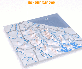 Places with similar names to Kampung Jeram, Malaysia ::
// Kampong Jeram (MY)
// Kampong Jeram (MY)
// Kampong Jeram (MY)
// Kampong Jeram (MY)
// Kampong Jeram (MY)
// Kampong Jeram (MY)
// Kampong Jeram (MY)
// Kampong Jeram (MY)
// Kampong Jeram (MY)
// Kampong Jeram (MY)
Disclaimer :: Information on this page comes without warranty of any kind |
||
|
Where is Kampung Jeram? Elevation and coordinates ::
Latitude (lat): 5°48'0"N Longitude (lon): 102°22'0"E
Elevation (approx.): 24m (map arrows pan, magnifying glasses zoom) |
||
|
Visiting Kampung Jeram? Hotel/Accommodation ::
Book a hotel in Kampung Jeram Travel Guide ::
Buy a travel guide for Malaysia rental cars ::
car rental offers GPS waypoint ::
download a GPX waypoint (PoI) of Kampung Jeram for your GPS receiver
|
||