|
search place name
|
||
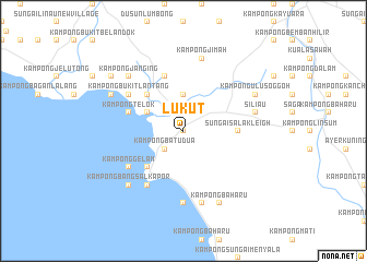
Lukut (Negeri Sembilan, Malaysia)Lukut is a town in the Negeri Sembilan region of Malaysia. An overview map of the region around Lukut is displayed below.
regional and 3d topo map of Lukut, Malaysia ::
nearby GPS traces from timatio ::
Lukut airports ::
The nearest airport is KUL - Kuala Lumpur Intl, located 24.1 km north west of Lukut.
Other airports nearby include MKZ - Malacca (57.3 km south east), DUM - Dumai Pinang Kampai (114.8 km south west), KUA - Kuantan (203.1 km north east), JHB - Johor Bahru Sultan Ismail (228.5 km south east), Nearby towns ::
Kampong Lukut (0.0km north) //
Kampong Batu Dua (2.6km south west) //
Kampong Paya (2.6km south west) //
Kampong Pengkalan Jenang (3.7km north) //
Kampong Telok Meranti (4.1km north west) //
Kampong Batu Lapan Belas (5.2km north west) //
Tanah Merah New Village (5.2km north west) //
Kampong Ayer Meleleh (5.2km south west) //
Kampong Arab (5.2km south west) //
Kampong Dhobi (5.2km south west) //
Sungai Salak Leigh (5.6km east) //
Sungai Salak (5.6km east) //
Kampong Baru (5.9km north) //
Kampong Telok (5.9km west) //
Kampung Kuala Lukut (5.9km west) //
Port Dickson (6.7km south west) //
Kampong Bukit Lantang (6.7km north west) //
Kampong Gelam (6.7km south west) //
Kampong Bagan Pinang (7.4km south) //
Kampong Jimah (7.6km north) //
Siliau (7.6km east) //
Kampong Si Rusa (7.6km south) //
Kampong Bangsal Kapor (7.9km south west) //
Kampong Janging (7.9km north west) //
Kampung Cuah (8.3km north west) //
Kampong Ulu Soggoh (8.3km north east) //
Kampong Baharu (8.3km south east) //
Kampong Sawah (9.3km north west) //
[all distances 'as the bird flies' and approximate] 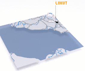 Places with similar names to Lukut, Malaysia ::
Disclaimer :: Information on this page comes without warranty of any kind |
||
|
Where is Lukut? Elevation and coordinates ::
Latitude (lat): 2°34'0"N Longitude (lon): 101°50'0"E
Elevation (approx.): 17m (map arrows pan, magnifying glasses zoom) |
||
|
Visiting Lukut? Hotel/Accommodation ::
Book a hotel in Lukut Travel Guide ::
Buy a travel guide for Malaysia rental cars ::
car rental offers GPS waypoint ::
download a GPX waypoint (PoI) of Lukut for your GPS receiver
|
||