|
search place name
|
||
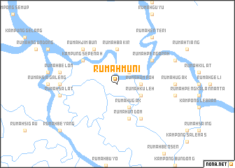
Rumah Muni (Sarawak, Malaysia)Rumah Muni is a town in the Sarawak region of Malaysia. An overview map of the region around Rumah Muni is displayed below.
regional and 3d topo map of Rumah Muni, Malaysia ::
Rumah Muni airports ::
The nearest airport is SBW - Sibu, located 48.8 km east of Rumah Muni.
Other airports nearby include KCH - Kuching Intl (162.4 km south west), BTU - Bintulu (186.3 km north east), Nearby towns ::
Kampong Penasu (2.6km north east) //
Rumah Bandan (2.6km north east) //
Rumah Umpoh (3.7km east) //
Rumah Kuleh (4.1km south east) //
Rumah Ugak (4.1km south east) //
Rumah Bakir (5.6km north) //
Rumah Entering (5.6km north) //
Rumah Undom (5.9km south) //
Rumah Abang (6.7km north west) //
Rumah Pengarah (6.7km north east) //
Kampung Sepenah (6.7km north west) //
Rumah Tiang (6.7km south east) //
Rumah Jimbun (7.9km north west) //
Rumah Enteri (9.3km north east) //
[all distances 'as the bird flies' and approximate] 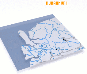 Places with similar names to Rumah Muni, Malaysia ::
// Rumah Man (MY)
Disclaimer :: Information on this page comes without warranty of any kind |
||
|
Where is Rumah Muni? Elevation and coordinates ::
Latitude (lat): 2°19'0"N Longitude (lon): 111°33'0"E
Elevation (approx.): 7m (map arrows pan, magnifying glasses zoom) |
||
|
Visiting Rumah Muni? Hotel/Accommodation ::
Book a hotel in Rumah Muni Travel Guide ::
Buy a travel guide for Malaysia rental cars ::
car rental offers GPS waypoint ::
download a GPX waypoint (PoI) of Rumah Muni for your GPS receiver
|
||