|
search place name
|
||
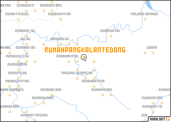
Rumah Pangkalan Tedong (Malaysia)Rumah Pangkalan Tedong is a town in Malaysia. An overview map of the region around Rumah Pangkalan Tedong is displayed below.
regional and 3d topo map of Rumah Pangkalan Tedong, Malaysia ::
Rumah Pangkalan Tedong airports ::
The nearest airport is SBW - Sibu, located 31.2 km north of Rumah Pangkalan Tedong.
Other airports nearby include BTU - Bintulu (167.2 km north east), KCH - Kuching Intl (195.6 km west), SQC - Sintang Susilo (221.2 km south), Nearby towns ::
Rumah Pulau Tadong (1.9km west) //
Rumah Gerina (1.9km east) //
Rumah Pengkalan Tedong (2.6km south west) //
Rumah Lang (2.6km south west) //
Rumah Jaul (2.6km south east) //
Rumah Rantal (3.7km west) //
Rumah Jawi (3.7km south) //
Tanjong Jerangku (4.1km south west) //
Rumah Antau (4.1km south west) //
Rumah Saoh (4.1km south east) //
Machan (4.1km north west) //
Rumah Kanchu (5.2km north west) //
Rumah Banyan (5.9km south) //
Rumah Nugu (6.7km north west) //
Rumah Sakai (7.9km north east) //
Rumah Nuang (8.3km south east) //
Rumah Menila (9.3km south east) //
Rumah Akaoh (10.5km south west) //
[all distances 'as the bird flies' and approximate]  Places with similar names to Rumah Pangkalan Tedong, Malaysia ::
// Rumah Pengkalan Tedong (MY)
Disclaimer :: Information on this page comes without warranty of any kind |
||
|
Where is Rumah Pangkalan Tedong? Elevation and coordinates ::
Latitude (lat): 1°59'0"N Longitude (lon): 112°2'0"E
Elevation (approx.): 131m (map arrows pan, magnifying glasses zoom) |
||
|
Visiting Rumah Pangkalan Tedong? Hotel/Accommodation ::
Book a hotel in Rumah Pangkalan Tedong Travel Guide ::
Buy a travel guide for Malaysia rental cars ::
car rental offers GPS waypoint ::
download a GPX waypoint (PoI) of Rumah Pangkalan Tedong for your GPS receiver
|
||