|
search place name
|
||
Rumah Tinggi (Sarawak, Malaysia)Rumah Tinggi is a town in the Sarawak region of Malaysia. An overview map of the region around Rumah Tinggi is displayed below.
regional and 3d topo map of Rumah Tinggi, Malaysia ::

Rumah Tinggi airports ::
The nearest airport is MYY - Miri, located 45.2 km north of Rumah Tinggi.
Other airports nearby include MUR - Marudi (51.9 km north east), BTU - Bintulu (134.1 km south west), LMN - Limbang (155.0 km north east), BWN - Brunei Intl (158.5 km north east), Nearby towns ::
Rumah Anggon (2.6km south west) //
Rumah Umeh (4.1km north east) //
Rumah Jelani (5.6km south) //
Rumah Entebang (7.6km north) //
Rumah Peng Kalan Barat (7.6km north) //
Rumah Umgon (7.6km east) //
[all distances 'as the bird flies' and approximate] 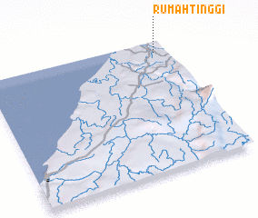 Places with similar names to Rumah Tinggi, Malaysia ::
// Riemading (DE)
// Rumah Danggoh (MY)
// Rumah Dingai (MY)
// Rumah Dinggai (MY)
// Rumah Dinggai (MY)
// Rumah Diong (MY)
// Rumah Dunggau (MY)
// Rumah Tangue (MY)
// Rumah Tinggi (MY)
// Rumah Tinggi (MY)
Disclaimer :: Information on this page comes without warranty of any kind |
||
|
Where is Rumah Tinggi? Elevation and coordinates ::
Latitude (lat): 3°55'0"N Longitude (lon): 113°56'0"E
Elevation (approx.): 19m (map arrows pan, magnifying glasses zoom) |
||
|
Visiting Rumah Tinggi? Hotel/Accommodation ::
Book a hotel in Rumah Tinggi Travel Guide ::
Buy a travel guide for Malaysia rental cars ::
car rental offers GPS waypoint ::
download a GPX waypoint (PoI) of Rumah Tinggi for your GPS receiver
|
||