|
search place name
|
||
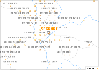
Segamat (Johor, Malaysia)Segamat is a town in the Johor region of Malaysia. An overview map of the region around Segamat is displayed below.
regional and 3d topo map of Segamat, Malaysia ::
Segamat airports ::
The nearest airport is MKZ - Malacca, located 68.1 km south west of Segamat.
Other airports nearby include KUL - Kuala Lumpur Intl (126.0 km west), JHB - Johor Bahru Sultan Ismail (134.2 km south east), KUA - Kuantan (147.6 km north), XSP - Singapore Seletar (167.4 km south east), Nearby towns ::
Kampong Abdullah (1.9km east) //
Kampong Padang Lalang (1.9km east) //
Kampong Tengah (1.9km north) //
Kampong Danau Panjang (1.9km south) //
Kampong Kenawar (1.9km south) //
Kampong Bukit Gubah (1.9km north) //
Kampong Lubok Batu (1.9km west) //
Kampong Berata (1.9km west) //
Kampong Gemereh (1.9km west) //
Kampong Paya Pulai (2.6km south east) //
Kampong Tengah Village (2.6km north east) //
Kampong Jawa (2.6km north east) //
Kampong Sedeng (2.6km south east) //
Kampong Gudang Garam (2.6km north west) //
Kampong Tahang Rimau (2.6km north west) //
Kampong Batu Hampar (2.6km north west) //
Kampung Tengah (3.7km north) //
Kampong Lubok Selumar (3.7km south) //
Kampong Mengkudu (3.7km north) //
Kampong Alai (3.7km west) //
Bukit Siput (4.1km south east) //
Kampong Kadut (4.1km north west) //
Kampong Bumbun (4.1km north west) //
Kampong Pogoh (4.1km south west) //
Kampong Tangga Batu (4.1km north west) //
Kampong Tengkoi (4.1km south west) //
Kampong Jabi (4.1km north west) //
Kampong Batu Badak (4.1km south west) //
Kampong Bukit Tangkong (4.1km north west) //
[all distances 'as the bird flies' and approximate] 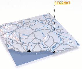 Places with similar names to Segamat, Malaysia ::
Disclaimer :: Information on this page comes without warranty of any kind |
||
|
Where is Segamat? Elevation and coordinates ::
Latitude (lat): 2°30'0"N Longitude (lon): 102°49'0"E
Elevation (approx.): 19m (map arrows pan, magnifying glasses zoom) |
||
|
Visiting Segamat? Hotel/Accommodation ::
Book a hotel in Segamat Travel Guide ::
Buy a travel guide for Malaysia rental cars ::
car rental offers GPS waypoint ::
download a GPX waypoint (PoI) of Segamat for your GPS receiver
|
||