|
search place name
|
||
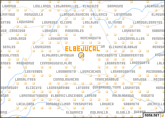
El Bejucal (Herrera, Panama)El Bejucal is a town in the Herrera region of Panama. An overview map of the region around El Bejucal is displayed below.
regional and 3d topo map of El Bejucal, Panama ::
El Bejucal airports ::
The nearest airport is HOW - Howard, located 178.3 km north east of El Bejucal.
Other airports nearby include PAC - Panama Marcos A Gelabert Intl (186.2 km north east), DAV - David Enrique Malek Intl (190.5 km west), PTY - Panama City Tocumen Intl (207.6 km north east), BOC - Bocas Del Toro Intl (230.9 km north west), Nearby towns ::
Río Parita (0.0km north) //
Los Helechales (2.6km south west) //
Quebrada Risacua (2.6km north east) //
El Guarumal (3.7km east) //
La Fragua (3.7km west) //
Cerro Largo (3.7km west) //
Los Bajos del Cuscú (3.7km north) //
La Malaguetosa (3.7km north) //
El Gallote (4.1km south east) //
El Plan (4.1km south west) //
Los Picachos (4.1km south east) //
Menchaquita (4.1km north east) //
Cerro Colorado (5.2km south east) //
La Sabaneta (5.2km south west) //
Menchaca (5.2km north east) //
Los Cañafístulos (5.2km north west) //
Nance Bonito (5.5km east) //
Mejías Arriba (5.5km east) //
El Salero (5.6km south) //
El Bebedero (5.8km east) //
Los Calabacitos (5.8km west) //
Cerro Colorado (5.8km west) //
Entradero de Ángulo (5.8km west) //
Alto del Castillo (5.8km west) //
Mejía Abajo (5.8km east) //
Navarro (5.8km east) //
El Suay Arriba (5.9km south) //
Llano Amador (5.9km south) //
Las Lomas Arriba (5.9km south) //
[all distances 'as the bird flies' and approximate]  Places with similar names to El Bejucal, Panama ::
// El Bejucal (GT)
// El Bijagual (GT)
// El Bijagual (GT)
// El Bejucal (MX)
// El Bejucal (MX)
// El Bejucal (MX)
// El Bejucal (HN)
// El Bejucal (HN)
// El Bijagual (HN)
// El Bejucal (VE)
Disclaimer :: Information on this page comes without warranty of any kind |
||
|
Where is El Bejucal? Elevation and coordinates ::
Latitude (lat): 7°50'0"N Longitude (lon): 80°48'0"W
Elevation (approx.): 303m (map arrows pan, magnifying glasses zoom) |
||
|
Visiting El Bejucal? Hotel/Accommodation ::
Book a hotel in El Bejucal Travel Guide ::
Buy a travel guide for Panama rental cars ::
car rental offers GPS waypoint ::
download a GPX waypoint (PoI) of El Bejucal for your GPS receiver
|
||