|
search place name
|
||
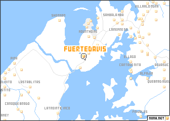
Fuerte Davis (Colón, Panama)Fuerte Davis is a town in the Colón region of Panama. An overview map of the region around Fuerte Davis is displayed below.
regional and 3d topo map of Fuerte Davis, Panama ::
Fuerte Davis airports ::
The nearest airport is PAC - Panama Marcos A Gelabert Intl, located 51.9 km south east of Fuerte Davis.
Other airports nearby include HOW - Howard (53.2 km south east), PTY - Panama City Tocumen Intl (62.3 km east), Nearby towns ::
Mindi Dairy Farm (1.8km north east) //
Gatún (2.0km south west) //
Brazos Heights (4.4km north east) //
Gulick Heights (4.4km north east) //
Mount Hope (5.4km north) //
Margarita (5.5km north) //
Cristóbal (7.4km north) //
Majagual-Gold Hill (7.6km north) //
Rainbow City (7.6km north) //
Colón (8.2km north) //
Nuevo Cristóbal (8.8km north) //
La Represa (9.4km north east) //
Sherman (10.5km north west) //
Cativá (10.9km north east) //
Pueblo Nuevo (11.4km north east) //
[all distances 'as the bird flies' and approximate] 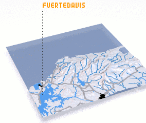 Places with similar names to Fuerte Davis, Panama ::
Disclaimer :: Information on this page comes without warranty of any kind |
||
|
Where is Fuerte Davis? Elevation and coordinates ::
Latitude (lat): 9°17'8"N Longitude (lon): 79°54'27"W
Elevation (approx.): 13m (map arrows pan, magnifying glasses zoom) |
||
|
Visiting Fuerte Davis? Hotel/Accommodation ::
Book a hotel in Fuerte Davis Travel Guide ::
Buy a travel guide for Panama rental cars ::
car rental offers GPS waypoint ::
download a GPX waypoint (PoI) of Fuerte Davis for your GPS receiver
|
||