|
search place name
|
||
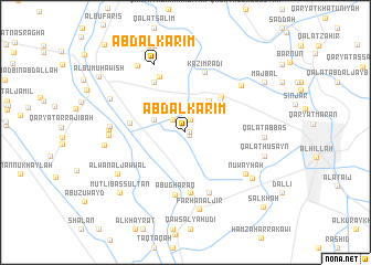
‘Abd al Karīm (Bābil, Iraq)‘Abd al Karīm is a town in the Bābil region of Iraq. An overview map of the region around ‘Abd al Karīm is displayed below.
regional and 3d topo map of ‘Abd al Karīm, Iraq ::
Nearby towns ::
Kāz̧im ‘Abd al Ḩasan (0.3km east) //
Ḩusayn ‘Abd ‘Alī (0.4km south east) //
Qaryat Ţalmāţah (1.4km north) //
Kāz̧im al ‘Ulwān (1.4km north) //
Shaykh Ḩusayn (1.7km north west) //
Bayt Sayyid Ḩabīb (3.0km north west) //
Qal‘at Ḩājjī Shukrī (3.8km north east) //
‘Awrān (4.4km north east) //
Abū Gharaq (4.8km north east) //
Qaryat Zu‘ayb (4.8km west) //
Qal‘at Salmān Mūsá (5.7km north west) //
Banī Şāliḩ (6.1km south) //
Ḩayyūm (6.1km north) //
Kāz̧im Rāḑī (6.3km north) //
Abū Gharaq (6.4km south) //
Ḩājjī Ḩasan (6.4km south) //
Qaryat al Khawāş (6.7km north east) //
Nuwayḩah (6.7km south east) //
‘Abd al Karīm (7.4km north) //
Ţāriq ‘Abbās (6.5km west) //
Mutawassiţat al Ḩayrāt (6.6km west) //
Qaryat Bayḑ Hilālāt (6.6km west) //
Farḩān al Jīr (7.9km south) //
Qal‘at ‘Abbās (6.7km east) //
‘Alwān al Jawwāl (7.2km south west) //
Ţahmāzīyah (7.3km south east) //
‘Arab al Kuraydāt (7.8km north west) //
As Sayyid Mahdī (7.0km west) //
Qal‘at Ḩusayn (7.1km east) //
[all distances 'as the bird flies' and approximate] 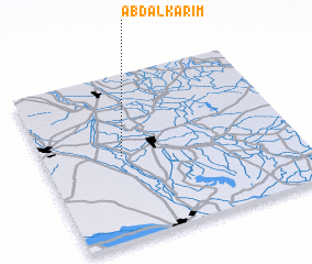 Places with similar names to ‘Abd al Karīm, Iraq ::
// Abdul Karīm (PK)
// ‘Abd al Karīm (IQ)
// ‘Abd al Karīm (IQ)
// ‘Abd al Karīm (IQ)
// ‘Abd al Karīm (IQ)
// ‘Abd ol Karīmī (IR)
// ‘Abd al Karīm (SD)
// ‘Abd al Karīm (SD)
// Abd el Krîm (DZ)
// Abdul Karīm (PK)
Disclaimer :: Information on this page comes without warranty of any kind |
||
|
Where is ‘Abd al Karīm? Elevation and coordinates ::
Latitude (lat): 32°30'17"N Longitude (lon): 44°18'43"E
Elevation (approx.): 28m (map arrows pan, magnifying glasses zoom) |
||
|
Visiting ‘Abd al Karīm? Hotel/Accommodation ::
Book a hotel in ‘Abd al Karīm Travel Guide ::
Buy a travel guide for Iraq rental cars ::
car rental offers GPS waypoint ::
download a GPX waypoint (PoI) of ‘Abd al Karīm for your GPS receiver
|
||