|
search place name
|
||
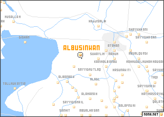
Ālbū Şinwān (Maysān, Iraq)Ālbū Şinwān is a town in the Maysān region of Iraq. An overview map of the region around Ālbū Şinwān is displayed below.
regional and 3d topo map of Ālbū Şinwān, Iraq ::
Ālbū Şinwān airports ::
The nearest airport is BSR - Basrah Intl, located 149.3 km south of Ālbū Şinwān.
Other airports nearby include AWZ - Ahwaz (167.4 km east), ABD - Abadan (192.4 km south east), Nearby towns ::
Al Jirjān (2.4km south west) //
Suwaylim (3.2km east) //
Harif (4.0km south east) //
Sayyid Muţlaq (4.0km south east) //
‘Abd al Ḩamīd (5.1km east) //
Anţūn Naşrānī (5.1km east) //
Karīm al Barbū (5.1km east) //
Al Barbaw (6.0km south west) //
Al ‘Adl (6.5km south east) //
Az Za‘līyah (6.9km south) //
Nāḩūm (6.3km east) //
Salaf Kāz̧im (7.5km south) //
‘Aţshān (6.6km east) //
Mizhān (7.3km south west) //
Sayyid ‘Abbās (7.3km north east) //
Ḩājjī Şāliḩ (8.1km north east) //
Farḩān (8.3km south east) //
‘Askar (9.7km south east) //
Ath Thābandar (9.7km south east) //
Sayyid Khalaf (11.1km south east) //
[all distances 'as the bird flies' and approximate] 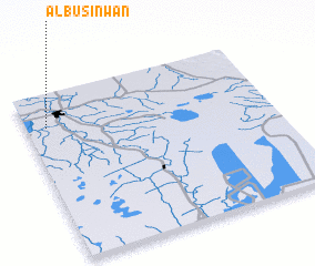 Places with similar names to Ālbū Şinwān, Iraq :: Disclaimer :: Information on this page comes without warranty of any kind |
||
|
Where is Ālbū Şinwān? Elevation and coordinates ::
Latitude (lat): 31°48'0"N Longitude (lon): 47°5'0"E
Elevation (approx.): 6m (map arrows pan, magnifying glasses zoom) |
||
|
Visiting Ālbū Şinwān? Hotel/Accommodation ::
Book a hotel in Ālbū Şinwān Travel Guide ::
Buy a travel guide for Iraq rental cars ::
car rental offers GPS waypoint ::
download a GPX waypoint (PoI) of Ālbū Şinwān for your GPS receiver
|
||