|
search place name
|
||
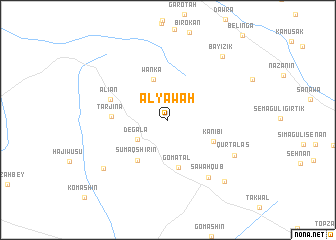
Alyāwah (Arbīl, Iraq)Alyāwah is a town in the Arbīl region of Iraq. An overview map of the region around Alyāwah is displayed below.
regional and 3d topo map of Alyāwah, Iraq ::
Alyāwah airports ::
The nearest airport is TBZ - Tabriz Intl, located 269.1 km north east of Alyāwah.
Nearby towns ::
Dēgala (3.5km south west) //
Wanka (4.7km north) //
Gomatal (5.4km south) //
Kānī Bī (4.7km south east) //
Sumaq Shirin (5.3km south west) //
Tarjīna (5.1km west) //
Alian (5.7km north west) //
Sāwah Qūb (7.4km south east) //
Qūrtālās (7.1km south east) //
Sumaq Shirin Bchook (7.9km south west) //
Pīrāl (8.6km south east) //
Bāyīzik (8.6km north east) //
[all distances 'as the bird flies' and approximate] 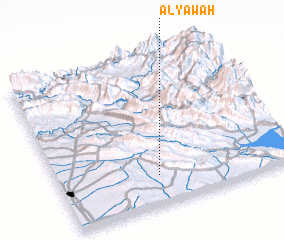 Places with similar names to Alyāwah, Iraq ::
// Awliyāwah (IQ)
Disclaimer :: Information on this page comes without warranty of any kind |
||
|
Where is Alyāwah? Elevation and coordinates ::
Latitude (lat): 36°11'39"N Longitude (lon): 44°25'1"E
Elevation (approx.): 766m (map arrows pan, magnifying glasses zoom) |
||
|
Visiting Alyāwah? Hotel/Accommodation ::
Book a hotel in Alyāwah Travel Guide ::
Buy a travel guide for Iraq rental cars ::
car rental offers GPS waypoint ::
download a GPX waypoint (PoI) of Alyāwah for your GPS receiver
|
||