|
search place name
|
||
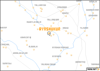
‘Ayn Shukūr (Diyālá, Iraq)‘Ayn Shukūr is a town in the Diyālá region of Iraq. An overview map of the region around ‘Ayn Shukūr is displayed below.
regional and 3d topo map of ‘Ayn Shukūr, Iraq ::
Nearby towns ::
Qilābāt (0.3km east) //
Gīlābāt (1.1km east) //
Razuq (1.8km north) //
Qumbat Hamzah (3.6km north) //
Tall Naqqār (4.9km north) //
Muwayliḩ Aḩmad Falaf (4.5km north west) //
Ḩadīdī (5.2km east) //
Sanājirah (5.6km east) //
Askī Kifrī (6.4km north east) //
‘Ayn Shukr Saghīr (6.6km south east) //
Muwayliḩ Sālim (6.3km north west) //
Jibbārah (6.5km east) //
Ālbū ‘Alik (7.3km south west) //
Kahrīz ‘Atīq (7.6km west) //
Şārī Garīl (8.3km north west) //
Archān (8.7km north west) //
Al Faqqah (8.6km south east) //
Haddām (7.9km south west) //
Kahrīz (8.8km north east) //
Şufşāfah (9.9km south east) //
[all distances 'as the bird flies' and approximate]  Places with similar names to ‘Ayn Shukūr, Iraq ::
Disclaimer :: Information on this page comes without warranty of any kind |
||
|
Where is ‘Ayn Shukūr? Elevation and coordinates ::
Latitude (lat): 34°35'3"N Longitude (lon): 44°51'47"E
Elevation (approx.): 145m (map arrows pan, magnifying glasses zoom) |
||
|
Visiting ‘Ayn Shukūr? Hotel/Accommodation ::
Book a hotel in ‘Ayn Shukūr Travel Guide ::
Buy a travel guide for Iraq rental cars ::
car rental offers GPS waypoint ::
download a GPX waypoint (PoI) of ‘Ayn Shukūr for your GPS receiver
|
||