|
search place name
|
||
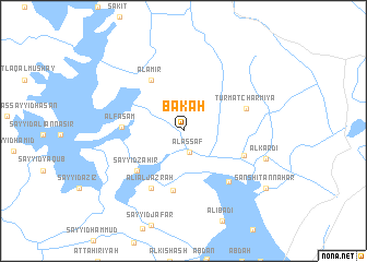
Bak‘ah (Dhī Qār, Iraq)Bak‘ah is a town in the Dhī Qār region of Iraq. An overview map of the region around Bak‘ah is displayed below.
regional and 3d topo map of Bak‘ah, Iraq ::
Bak‘ah airports ::
The nearest airport is BSR - Basrah Intl, located 139.2 km south east of Bak‘ah.
Other airports nearby include ABD - Abadan (194.9 km south east), Nearby towns ::
Al ‘Assāf (2.3km south) //
‘Abd al Ḩusayn (6.1km south) //
Al ‘Amīr (5.9km north west) //
Sayyid Z̧āhir (5.7km south west) //
Al Faşām (5.4km west) //
Ţāhir al Khulaywī (5.8km south east) //
‘Alī al Jazrah (6.5km south west) //
Turmat Charmīya (5.9km east) //
An Nahār (6.6km south east) //
Al Kardī (7.7km east) //
Sanshit an Nahār (9.3km south east) //
[all distances 'as the bird flies' and approximate] 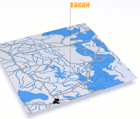 Places with similar names to Bak‘ah, Iraq ::
Disclaimer :: Information on this page comes without warranty of any kind |
||
|
Where is Bak‘ah? Elevation and coordinates ::
Latitude (lat): 31°19'11"N Longitude (lon): 46°30'45"E
Elevation (approx.): 7m (map arrows pan, magnifying glasses zoom) |
||
|
Visiting Bak‘ah? Hotel/Accommodation ::
Book a hotel in Bak‘ah Travel Guide ::
Buy a travel guide for Iraq rental cars ::
car rental offers GPS waypoint ::
download a GPX waypoint (PoI) of Bak‘ah for your GPS receiver
|
||