|
search place name
|
||
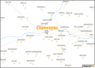
Chami Korak (Dahūk, Iraq)Chami Korak is a town in the Dahūk region of Iraq. An overview map of the region around Chami Korak is displayed below.
regional and 3d topo map of Chami Korak, Iraq ::
Chami Korak airports ::
The nearest airport is BAL - Batman, located 158.0 km north west of Chami Korak.
Other airports nearby include VAN - Van (160.1 km north east), Nearby towns ::
Khēlākh (2.1km south) //
Chammīshko (2.2km north east) //
Bagirma (2.2km south west) //
Kharāb Dār (2.9km south east) //
Dūrnāq (3.2km north) //
Kapılı (3.3km north west) //
Sālgā (4.1km south east) //
Khishtāna (4.6km north) //
Bēdār (4.2km east) //
Āfarma (4.7km east) //
Rbinka (6.3km north) //
Pāchūka (5.8km west) //
Muhamadi (5.8km east) //
Kōzāvā (7.5km north) //
Kānī Rahl (7.0km south east) //
Ashkaft-ē Mārā (6.5km east) //
Zakho (7.0km east) //
Aktepe (7.2km west) //
Kharbanor (8.6km south west) //
Hasanāwā (8.2km south east) //
Karnē (8.7km north east) //
Kūlī (8.6km south east) //
Galī Zākhō (9.3km south) //
Kharbātūr (9.5km south west) //
Verimli (9.0km north west) //
Barāv (9.9km south west) //
Barzīr (10.0km north east) //
[all distances 'as the bird flies' and approximate] 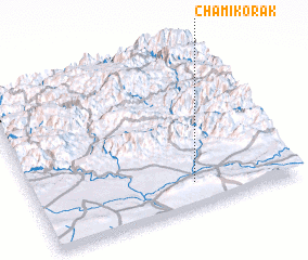 Places with similar names to Chami Korak, Iraq ::
Disclaimer :: Information on this page comes without warranty of any kind |
||
|
Where is Chami Korak? Elevation and coordinates ::
Latitude (lat): 37°8'41"N Longitude (lon): 42°36'29"E
Elevation (approx.): 421m (map arrows pan, magnifying glasses zoom) |
||
|
Visiting Chami Korak? Hotel/Accommodation ::
Book a hotel in Chami Korak Travel Guide ::
Buy a travel guide for Iraq rental cars ::
car rental offers GPS waypoint ::
download a GPX waypoint (PoI) of Chami Korak for your GPS receiver
|
||