|
search place name
|
||
Dallī Abū Jamīl (Bābil, Iraq)Dallī Abū Jamīl is a town in the Bābil region of Iraq. An overview map of the region around Dallī Abū Jamīl is displayed below.
regional and 3d topo map of Dallī Abū Jamīl, Iraq ::
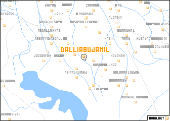
Nearby towns ::
Ḩulaybah (1.6km east) //
Daḩḩām (1.9km north) //
Muḩammad al Ḩusayn (2.3km north west) //
Muḩammad al Ḩasan (2.4km south west) //
‘Abīr al Murhij (4.0km south west) //
Durayb (3.6km north east) //
Khuraymah (4.0km south west) //
Mushīr al ‘Umar (4.3km south east) //
‘Abd ash Shakhīr (4.7km south east) //
Jāsim (4.9km north west) //
‘Askar (4.7km west) //
Naqībat ash Shukr (5.8km south) //
Kullāb al Mahnāʼ (6.3km south) //
Kāz̧im (6.0km north east) //
Murād al Khalīl (6.8km north east) //
Mayāmah (6.3km east) //
Ḩusayn al Farmān (7.4km north) //
Ţulay‘ah (8.0km south east) //
Dawḩān (7.3km north west) //
As Sayyid ‘Abd Allāh (7.3km north west) //
Muḩammad as Sulţān (7.2km west) //
Qal‘at ash Shaykh Kitāb (8.8km south east) //
Umm ar Rīsh (8.4km south east) //
‘Abd Allāh Kāz̧im (8.4km north west) //
‘Alwān al Ḩusayn (9.7km north east) //
Ḩufrah (9.7km north west) //
‘Abd al Ḩusayn (9.7km north west) //
Al Qāsim (10.1km north east) //
[all distances 'as the bird flies' and approximate] 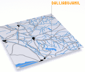 Places with similar names to Dallī Abū Jamīl, Iraq :: Disclaimer :: Information on this page comes without warranty of any kind |
||
|
Where is Dallī Abū Jamīl? Elevation and coordinates ::
Latitude (lat): 32°14'0"N Longitude (lon): 44°37'0"E
Elevation (approx.): 22m (map arrows pan, magnifying glasses zoom) |
||
|
Visiting Dallī Abū Jamīl? Hotel/Accommodation ::
Book a hotel in Dallī Abū Jamīl Travel Guide ::
Buy a travel guide for Iraq rental cars ::
car rental offers GPS waypoint ::
download a GPX waypoint (PoI) of Dallī Abū Jamīl for your GPS receiver
|
||